You are here: Home > Network List > TA - USArray Transportable Network (new EarthScope stations) Stations List
> Station Q23K Middleton Island, AK, USA > Earthquake Result Viewer
Q23K Middleton Island, AK, USA - Earthquake Result Viewer
| Earthquake location: |
Northern Peru |
| Earthquake latitude/longitude: |
-5.9/-75.3 |
| Earthquake time(UTC): |
2019/05/26 (146) 07:41:13 GMT |
| Earthquake Depth: |
105 km |
| Earthquake Magnitude: |
7.5 Mi |
| Earthquake Catalog/Contributor: |
NEIC PDE/at |
|
| Network: |
TA USArray Transportable Network (new EarthScope stations) |
| Station: |
Q23K Middleton Island, AK, USA |
| Lat/Lon: |
59.43 N/146.35 W |
| Elevation: |
46 m |
|
| Distance: |
85.6 deg |
| Az: |
330.995 deg |
| Baz: |
109.32 deg |
| Ray Param: |
0.044451073 |
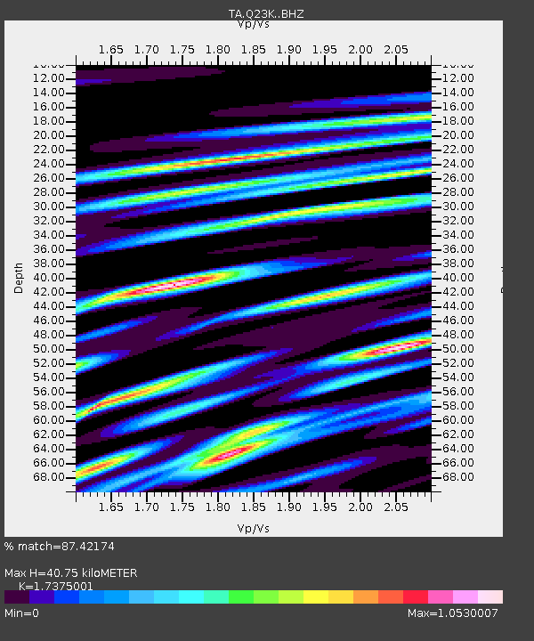
| Estimated Moho Depth: |
40.75 km |
| Estimated Crust Vp/Vs: |
1.74 |
| Assumed Crust Vp: |
5.989 km/s |
| Estimated Crust Vs: |
3.447 km/s |
| Estimated Crust Poisson's Ratio: |
0.25 |
|
| Radial Match: |
87.42174 % |
| Radial Bump: |
400 |
| Transverse Match: |
83.60444 % |
| Transverse Bump: |
400 |
| SOD ConfigId: |
18369291 |
| Insert Time: |
2019-06-09 07:52:48.714 +0000 |
| GWidth: |
2.5 |
| Max Bumps: |
400 |
| Tol: |
0.001 |
|

Signal To Noise
| Channel | StoN | STA | LTA |
| TA:Q23K: :BHZ:20190526T07:53:08.349976Z | 9.1416855 | 1.0568002E-5 | 1.1560235E-6 |
| TA:Q23K: :BHN:20190526T07:53:08.349976Z | 1.487244 | 1.7825914E-6 | 1.1985871E-6 |
| TA:Q23K: :BHE:20190526T07:53:08.349976Z | 1.9699479 | 2.7863275E-6 | 1.4144168E-6 |
| Arrivals |
| Ps | 5.1 SECOND |
| PpPs | 18 SECOND |
| PsPs/PpSs | 23 SECOND |


