You are here: Home > Network List > TA - USArray Transportable Network (new EarthScope stations) Stations List
> Station R18K Karluk, AK, USA > Earthquake Result Viewer
R18K Karluk, AK, USA - Earthquake Result Viewer

| Earthquake location: |
Northern Peru |
| Earthquake latitude/longitude: |
-5.9/-75.3 |
| Earthquake time(UTC): |
2019/05/26 (146) 07:41:13 GMT |
| Earthquake Depth: |
105 km |
| Earthquake Magnitude: |
7.5 Mi |
| Earthquake Catalog/Contributor: |
NEIC PDE/at |
|
| Network: |
TA USArray Transportable Network (new EarthScope stations) |
| Station: |
R18K Karluk, AK, USA |
| Lat/Lon: |
57.57 N/154.45 W |
| Elevation: |
39 m |
|
| Distance: |
89.1 deg |
| Az: |
328.041 deg |
| Baz: |
102.284 deg |
| Ray Param: |
0.041849017 |
| Estimated Moho Depth: |
45.0 km |
| Estimated Crust Vp/Vs: |
1.69 |
| Assumed Crust Vp: |
6.24 km/s |
| Estimated Crust Vs: |
3.692 km/s |
| Estimated Crust Poisson's Ratio: |
0.23 |
|
| Radial Match: |
96.13789 % |
| Radial Bump: |
400 |
| Transverse Match: |
94.440674 % |
| Transverse Bump: |
400 |
| SOD ConfigId: |
18369291 |
| Insert Time: |
2019-06-09 07:52:50.319 +0000 |
| GWidth: |
2.5 |
| Max Bumps: |
400 |
| Tol: |
0.001 |
|
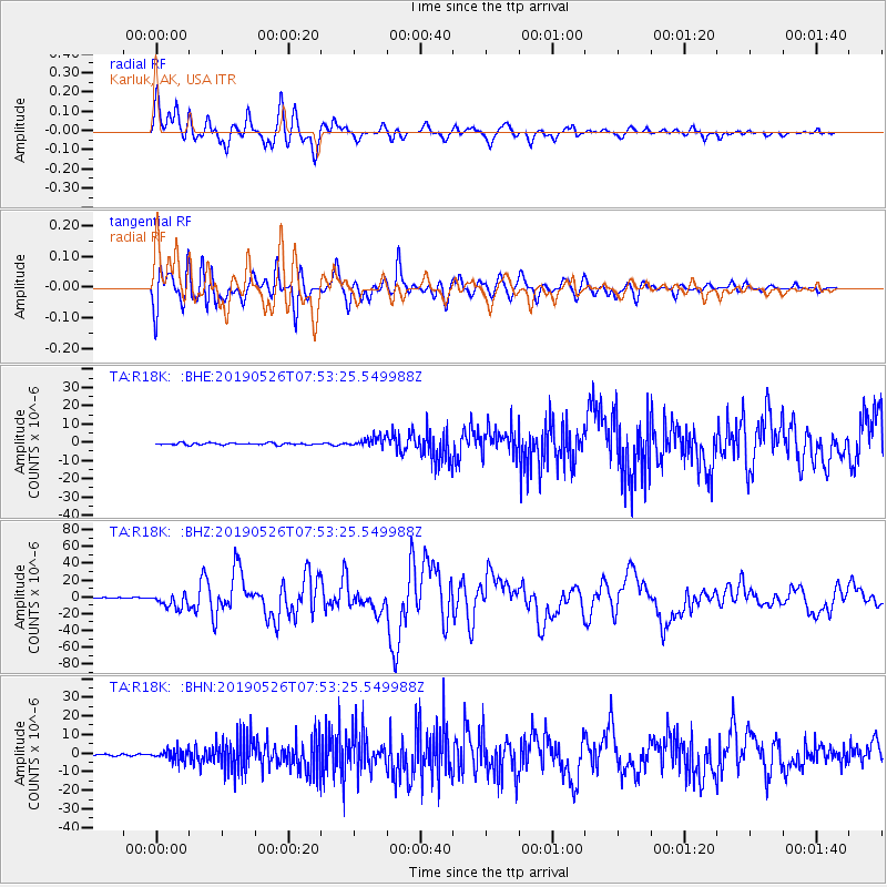
Signal To Noise
| Channel | StoN | STA | LTA |
| TA:R18K: :BHZ:20190526T07:53:25.549988Z | 15.577213 | 8.650689E-6 | 5.553425E-7 |
| TA:R18K: :BHN:20190526T07:53:25.549988Z | 5.3769164 | 3.084906E-6 | 5.737314E-7 |
| TA:R18K: :BHE:20190526T07:53:25.549988Z | 5.327075 | 2.737595E-6 | 5.139021E-7 |
| Arrivals |
| Ps | 5.1 SECOND |
| PpPs | 19 SECOND |
| PsPs/PpSs | 24 SECOND |


