You are here: Home > Network List > TA - USArray Transportable Network (new EarthScope stations) Stations List
> Station S14K Fog Glacier, AK, USA > Earthquake Result Viewer
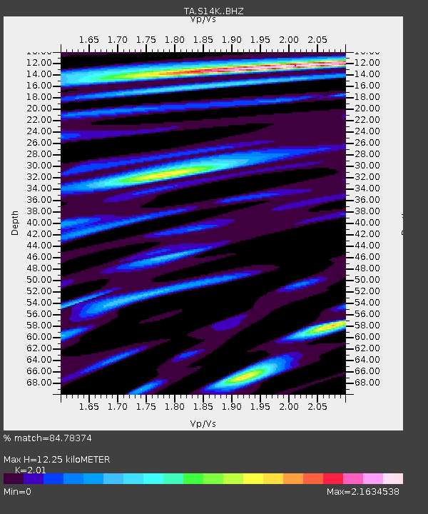
S14K Fog Glacier, AK, USA - Earthquake Result Viewer
| Earthquake location: |
Northern Peru |
| Earthquake latitude/longitude: |
-5.9/-75.3 |
| Earthquake time(UTC): |
2019/05/26 (146) 07:41:13 GMT |
| Earthquake Depth: |
105 km |
| Earthquake Magnitude: |
7.5 Mi |
| Earthquake Catalog/Contributor: |
NEIC PDE/at |
|
| Network: |
TA USArray Transportable Network (new EarthScope stations) |
| Station: |
S14K Fog Glacier, AK, USA |
| Lat/Lon: |
56.28 N/159.55 W |
| Elevation: |
1059 m |
|
| Distance: |
91.7 deg |
| Az: |
326.284 deg |
| Baz: |
98.03 deg |
| Ray Param: |
0.04153015 |
| Estimated Moho Depth: |
12.25 km |
| Estimated Crust Vp/Vs: |
2.01 |
| Assumed Crust Vp: |
6.134 km/s |
| Estimated Crust Vs: |
3.052 km/s |
| Estimated Crust Poisson's Ratio: |
0.34 |
|
| Radial Match: |
84.78374 % |
| Radial Bump: |
400 |
| Transverse Match: |
83.4341 % |
| Transverse Bump: |
400 |
| SOD ConfigId: |
18369291 |
| Insert Time: |
2019-06-09 07:52:52.887 +0000 |
| GWidth: |
2.5 |
| Max Bumps: |
400 |
| Tol: |
0.001 |
|

Signal To Noise
| Channel | StoN | STA | LTA |
| TA:S14K: :BHZ:20190526T07:53:37.224976Z | 4.164134 | 7.668856E-6 | 1.8416447E-6 |
| TA:S14K: :BHN:20190526T07:53:37.224976Z | 0.9091104 | 2.3669127E-6 | 2.603548E-6 |
| TA:S14K: :BHE:20190526T07:53:37.224976Z | 1.1687138 | 3.2747325E-6 | 2.801997E-6 |
| Arrivals |
| Ps | 2.1 SECOND |
| PpPs | 5.9 SECOND |
| PsPs/PpSs | 8.0 SECOND |


