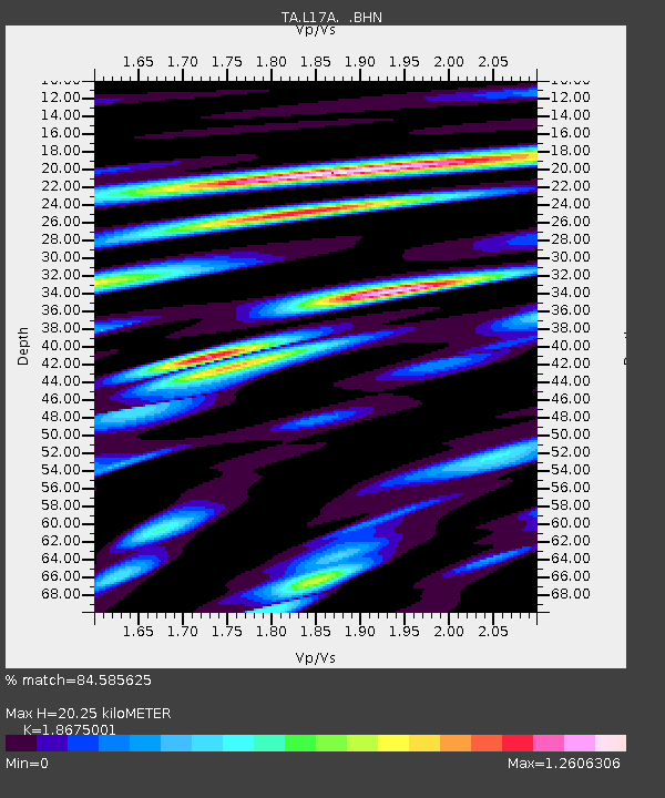
L17A Cokeville, WY, USA - Earthquake Result Viewer
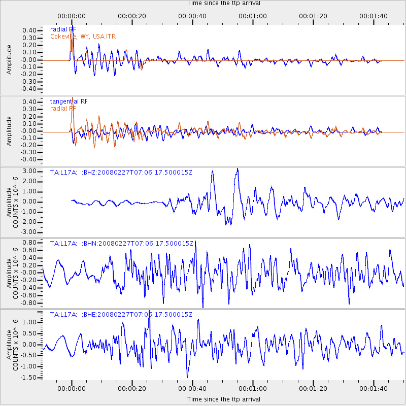
Earthquake location: Bonin Islands, Japan Region
Earthquake latitude/longitude: 26.8/142.4
Earthquake time(UTC): 2008/02/27 (058) 06:54:20 GMT
Earthquake Depth: 15 km
Earthquake Magnitude: 5.8 MB, 6.1 MS, 6.2 MW, 6.2 MW
Earthquake Catalog/Contributor: WHDF/NEIC
Network: TA USArray Transportable Network (new EarthScope stations)
Station: L17A Cokeville, WY, USA
Lat/Lon: 42.10 N/110.87 W
Elevation: 1996 m
Distance: 83.8 deg
Az: 45.817 deg
Baz: 300.556 deg
Ray Param: 0.04595079
Estimated Moho Depth: 20.25 km
Estimated Crust Vp/Vs: 1.87
Assumed Crust Vp: 6.207 km/s
Estimated Crust Vs: 3.324 km/s
Estimated Crust Poisson's Ratio: 0.30
Radial Match: 84.585625 %
Radial Bump: 400
Transverse Match: 68.2366 %
Transverse Bump: 400
SOD ConfigId: 2564
Insert Time: 2010-03-06 23:00:27.772 +0000
GWidth: 2.5
Max Bumps: 400
Tol: 0.001

Signal To Noise

ChannelStoNSTALTA
TA:L17A: :BHN:20080227T07:06:17.500015Z1.20126061.614169E-71.3437294E-7
TA:L17A: :BHE:20080227T07:06:17.500015Z2.48784043.5019053E-71.4076085E-7
TA:L17A: :BHZ:20080227T07:06:17.500015Z2.51752923.7436158E-71.4870197E-7
Arrivals
Ps2.9 SECOND
PpPs9.1 SECOND
PsPs/PpSs12 SECOND