You are here: Home > Network List > TX - Texas Seismological Network Stations List
> Station 833A Chaparral WMA, Artesia Wells, TX, USA > Earthquake Result Viewer
833A Chaparral WMA, Artesia Wells, TX, USA - Earthquake Result Viewer
| Earthquake location: |
Northern Peru |
| Earthquake latitude/longitude: |
-5.9/-75.3 |
| Earthquake time(UTC): |
2019/05/26 (146) 07:41:13 GMT |
| Earthquake Depth: |
105 km |
| Earthquake Magnitude: |
7.5 Mi |
| Earthquake Catalog/Contributor: |
NEIC PDE/at |
|
| Network: |
TX Texas Seismological Network |
| Station: |
833A Chaparral WMA, Artesia Wells, TX, USA |
| Lat/Lon: |
28.32 N/99.39 W |
| Elevation: |
171 m |
|
| Distance: |
41.2 deg |
| Az: |
326.881 deg |
| Baz: |
141.938 deg |
| Ray Param: |
0.073566586 |
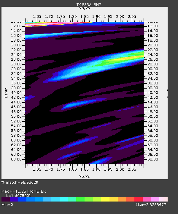
| Estimated Moho Depth: |
11.25 km |
| Estimated Crust Vp/Vs: |
1.61 |
| Assumed Crust Vp: |
6.347 km/s |
| Estimated Crust Vs: |
3.948 km/s |
| Estimated Crust Poisson's Ratio: |
0.18 |
|
| Radial Match: |
96.93029 % |
| Radial Bump: |
380 |
| Transverse Match: |
92.99939 % |
| Transverse Bump: |
400 |
| SOD ConfigId: |
18369291 |
| Insert Time: |
2019-06-09 07:53:03.451 +0000 |
| GWidth: |
2.5 |
| Max Bumps: |
400 |
| Tol: |
0.001 |
|

Signal To Noise
| Channel | StoN | STA | LTA |
| TX:833A: :BHZ:20190526T07:48:16.950012Z | 18.056293 | 1.277195E-5 | 7.0734063E-7 |
| TX:833A: :BHN:20190526T07:48:16.950012Z | 10.863309 | 5.0470735E-6 | 4.6459814E-7 |
| TX:833A: :BHE:20190526T07:48:16.950012Z | 12.70219 | 4.457388E-6 | 3.5091492E-7 |
| Arrivals |
| Ps | 1.2 SECOND |
| PpPs | 4.3 SECOND |
| PsPs/PpSs | 5.5 SECOND |


