You are here: Home > Network List > TX - Texas Seismological Network Stations List
> Station HNDO Hondo > Earthquake Result Viewer
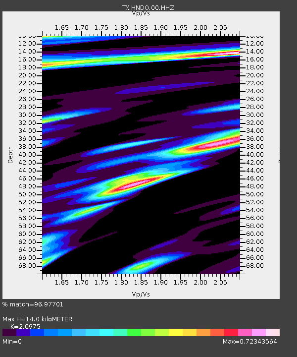
HNDO Hondo - Earthquake Result Viewer
| Earthquake location: |
Northern Peru |
| Earthquake latitude/longitude: |
-5.9/-75.3 |
| Earthquake time(UTC): |
2019/05/26 (146) 07:41:13 GMT |
| Earthquake Depth: |
105 km |
| Earthquake Magnitude: |
7.5 Mi |
| Earthquake Catalog/Contributor: |
NEIC PDE/at |
|
| Network: |
TX Texas Seismological Network |
| Station: |
HNDO Hondo |
| Lat/Lon: |
29.53 N/99.28 W |
| Elevation: |
381 m |
|
| Distance: |
42.1 deg |
| Az: |
328.102 deg |
| Baz: |
142.905 deg |
| Ray Param: |
0.07303379 |
| Estimated Moho Depth: |
14.0 km |
| Estimated Crust Vp/Vs: |
2.10 |
| Assumed Crust Vp: |
6.347 km/s |
| Estimated Crust Vs: |
3.026 km/s |
| Estimated Crust Poisson's Ratio: |
0.35 |
|
| Radial Match: |
96.97701 % |
| Radial Bump: |
304 |
| Transverse Match: |
95.08458 % |
| Transverse Bump: |
400 |
| SOD ConfigId: |
18369291 |
| Insert Time: |
2019-06-09 07:53:16.922 +0000 |
| GWidth: |
2.5 |
| Max Bumps: |
400 |
| Tol: |
0.001 |
|

Signal To Noise
| Channel | StoN | STA | LTA |
| TX:HNDO:00:HHZ:20190526T07:48:24.190002Z | 24.171824 | 1.7550348E-5 | 7.260664E-7 |
| TX:HNDO:00:HH1:20190526T07:48:24.190002Z | 10.956536 | 2.2315699E-6 | 2.0367474E-7 |
| TX:HNDO:00:HH2:20190526T07:48:24.190002Z | 17.571241 | 9.723822E-6 | 5.533941E-7 |
| Arrivals |
| Ps | 2.6 SECOND |
| PpPs | 6.5 SECOND |
| PsPs/PpSs | 9.0 SECOND |


