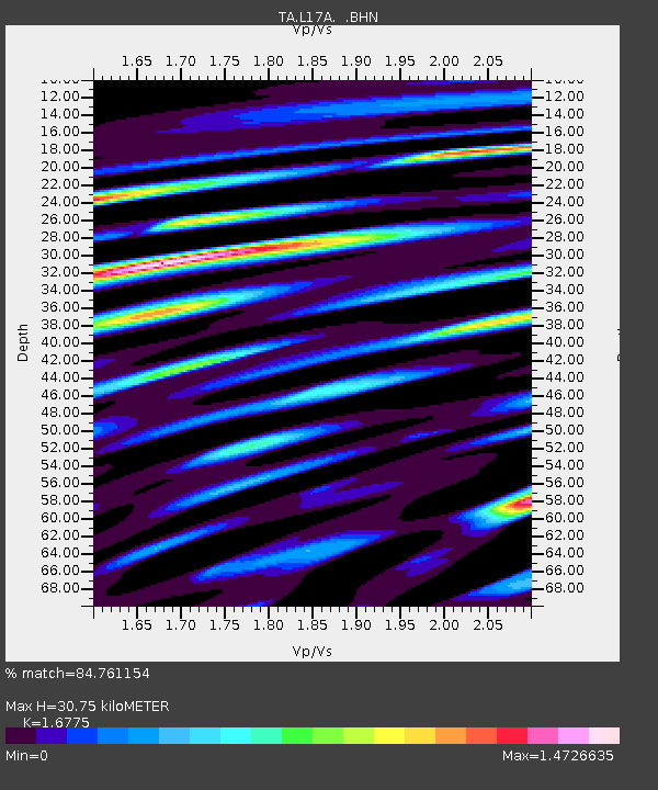
L17A Cokeville, WY, USA - Earthquake Result Viewer
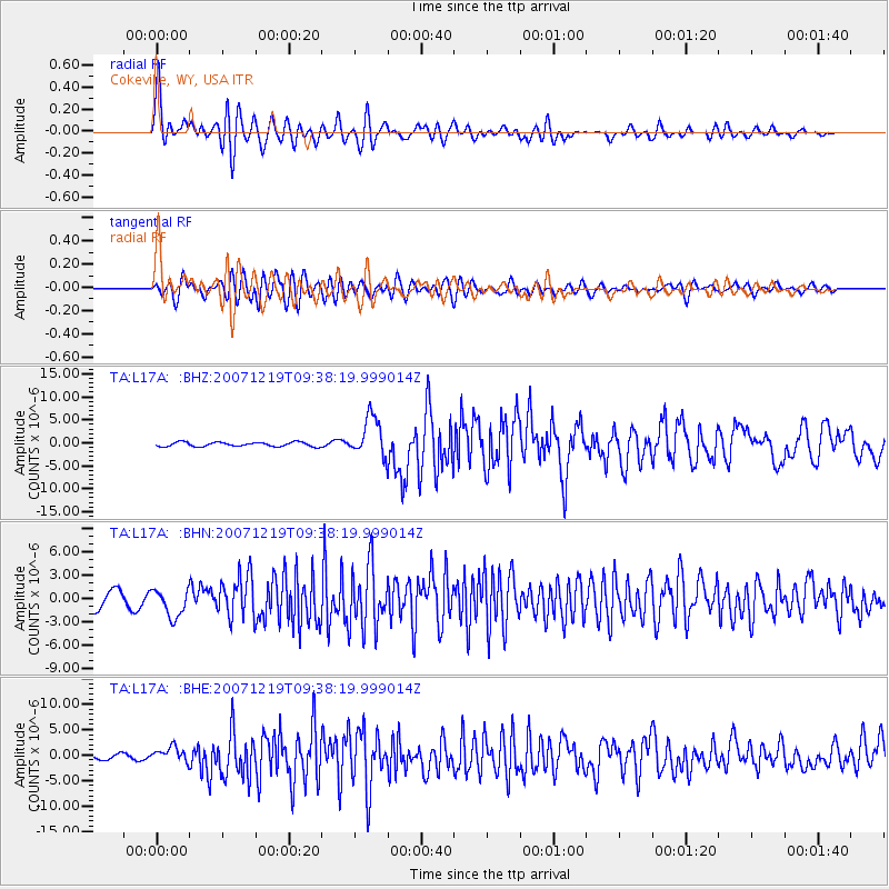
Earthquake location: Andreanof Islands, Aleutian Is.
Earthquake latitude/longitude: 51.4/-179.5
Earthquake time(UTC): 2007/12/19 (353) 09:30:27 GMT
Earthquake Depth: 29 km
Earthquake Magnitude: 6.4 MB, 7.1 MS, 7.1 MW, 7.0 MW
Earthquake Catalog/Contributor: WHDF/NEIC
Network: TA USArray Transportable Network (new EarthScope stations)
Station: L17A Cokeville, WY, USA
Lat/Lon: 42.10 N/110.87 W
Elevation: 1996 m
Distance: 46.4 deg
Az: 73.321 deg
Baz: 306.198 deg
Ray Param: 0.07064566
Estimated Moho Depth: 30.75 km
Estimated Crust Vp/Vs: 1.68
Assumed Crust Vp: 6.207 km/s
Estimated Crust Vs: 3.7 km/s
Estimated Crust Poisson's Ratio: 0.22
Radial Match: 84.761154 %
Radial Bump: 400
Transverse Match: 72.02037 %
Transverse Bump: 400
SOD ConfigId: 2564
Insert Time: 2010-03-06 23:00:45.250 +0000
GWidth: 2.5
Max Bumps: 400
Tol: 0.001

Signal To Noise

ChannelStoNSTALTA
TA:L17A: :BHN:20071219T09:38:19.999014Z1.7962531.8098602E-61.0075753E-6
TA:L17A: :BHE:20071219T09:38:19.999014Z2.6766441.4450928E-65.3988975E-7
TA:L17A: :BHZ:20071219T09:38:19.999014Z9.4105284.319756E-64.590344E-7
Arrivals
Ps3.6 SECOND
PpPs12 SECOND
PsPs/PpSs16 SECOND