You are here: Home > Network List > TA - USArray Transportable Network (new EarthScope stations) Stations List
> Station L17A Cokeville, WY, USA > Earthquake Result Viewer
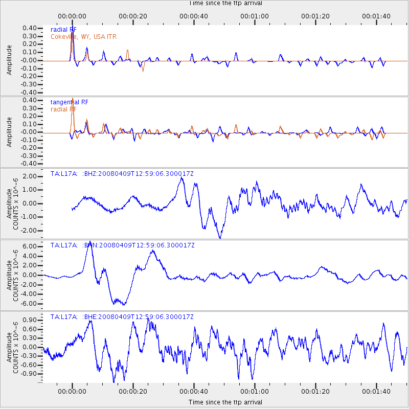
L17A Cokeville, WY, USA - Earthquake Result Viewer
| Earthquake location: |
Loyalty Islands |
| Earthquake latitude/longitude: |
-20.1/168.9 |
| Earthquake time(UTC): |
2008/04/09 (100) 12:46:12 GMT |
| Earthquake Depth: |
33 km |
| Earthquake Magnitude: |
6.3 MB, 7.3 MS, 7.3 MW, 7.3 MW |
| Earthquake Catalog/Contributor: |
WHDF/NEIC |
|
| Network: |
TA USArray Transportable Network (new EarthScope stations) |
| Station: |
L17A Cokeville, WY, USA |
| Lat/Lon: |
42.10 N/110.87 W |
| Elevation: |
1996 m |
|
| Distance: |
96.3 deg |
| Az: |
47.549 deg |
| Baz: |
248.743 deg |
| Ray Param: |
0.0405469 |
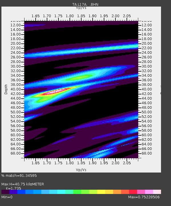
| Estimated Moho Depth: |
40.75 km |
| Estimated Crust Vp/Vs: |
1.74 |
| Assumed Crust Vp: |
6.207 km/s |
| Estimated Crust Vs: |
3.577 km/s |
| Estimated Crust Poisson's Ratio: |
0.25 |
|
| Radial Match: |
91.34595 % |
| Radial Bump: |
262 |
| Transverse Match: |
78.46456 % |
| Transverse Bump: |
400 |
| SOD ConfigId: |
2504 |
| Insert Time: |
2010-03-06 23:00:49.907 +0000 |
| GWidth: |
2.5 |
| Max Bumps: |
400 |
| Tol: |
0.001 |
|
Signal To Noise
| Channel | StoN | STA | LTA |
| TA:L17A: :BHN:20080409T12:59:06.300017Z | 10.688641 | 1.7227832E-6 | 1.6117889E-7 |
| TA:L17A: :BHE:20080409T12:59:06.300017Z | 2.1157117 | 3.5521273E-7 | 1.6789278E-7 |
| TA:L17A: :BHZ:20080409T12:59:06.300017Z | 1.4057693 | 4.774914E-7 | 3.3966558E-7 |
| Arrivals |
| Ps | 4.9 SECOND |
| PpPs | 18 SECOND |
| PsPs/PpSs | 23 SECOND |


