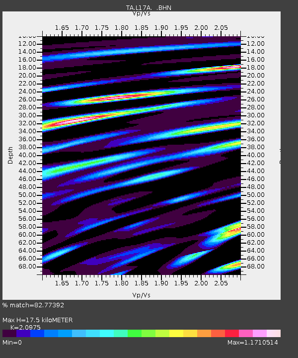
L17A Cokeville, WY, USA - Earthquake Result Viewer
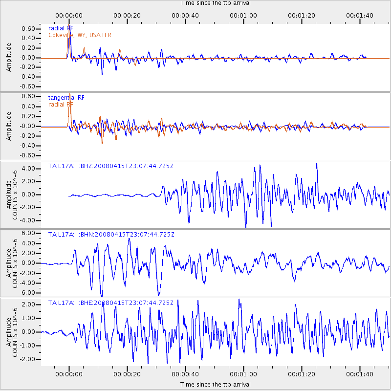
Earthquake location: Andreanof Islands, Aleutian Is.
Earthquake latitude/longitude: 51.9/-179.4
Earthquake time(UTC): 2008/04/15 (106) 22:59:51 GMT
Earthquake Depth: 10 km
Earthquake Magnitude: 6.1 MB, 6.4 MS, 6.4 MW, 6.4 MW
Earthquake Catalog/Contributor: WHDF/NEIC
Network: TA USArray Transportable Network (new EarthScope stations)
Station: L17A Cokeville, WY, USA
Lat/Lon: 42.10 N/110.87 W
Elevation: 1996 m
Distance: 46.1 deg
Az: 73.874 deg
Baz: 306.812 deg
Ray Param: 0.07084499
Estimated Moho Depth: 17.5 km
Estimated Crust Vp/Vs: 2.10
Assumed Crust Vp: 6.207 km/s
Estimated Crust Vs: 2.959 km/s
Estimated Crust Poisson's Ratio: 0.35
Radial Match: 82.77392 %
Radial Bump: 400
Transverse Match: 76.30643 %
Transverse Bump: 400
SOD ConfigId: 2504
Insert Time: 2010-03-06 23:00:51.349 +0000
GWidth: 2.5
Max Bumps: 400
Tol: 0.001

Signal To Noise

ChannelStoNSTALTA
TA:L17A: :BHN:20080415T23:07:44.725Z13.6157831.1911894E-68.748594E-8
TA:L17A: :BHE:20080415T23:07:44.725Z3.3456783.2739658E-79.785657E-8
TA:L17A: :BHZ:20080415T23:07:44.725Z7.16249237.0332203E-79.819515E-8
Arrivals
Ps3.3 SECOND
PpPs8.3 SECOND
PsPs/PpSs12 SECOND