You are here: Home > Network List > TX - Texas Seismological Network Stations List
> Station SN01 Snyder 1 > Earthquake Result Viewer
SN01 Snyder 1 - Earthquake Result Viewer
| Earthquake location: |
Northern Peru |
| Earthquake latitude/longitude: |
-5.9/-75.3 |
| Earthquake time(UTC): |
2019/05/26 (146) 07:41:13 GMT |
| Earthquake Depth: |
105 km |
| Earthquake Magnitude: |
7.5 Mi |
| Earthquake Catalog/Contributor: |
NEIC PDE/at |
|
| Network: |
TX Texas Seismological Network |
| Station: |
SN01 Snyder 1 |
| Lat/Lon: |
32.86 N/100.89 W |
| Elevation: |
717 m |
|
| Distance: |
45.6 deg |
| Az: |
329.402 deg |
| Baz: |
143.013 deg |
| Ray Param: |
0.07083174 |
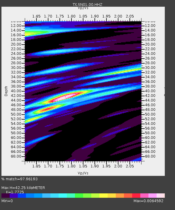
| Estimated Moho Depth: |
42.25 km |
| Estimated Crust Vp/Vs: |
1.77 |
| Assumed Crust Vp: |
6.426 km/s |
| Estimated Crust Vs: |
3.625 km/s |
| Estimated Crust Poisson's Ratio: |
0.27 |
|
| Radial Match: |
97.96193 % |
| Radial Bump: |
344 |
| Transverse Match: |
94.12482 % |
| Transverse Bump: |
397 |
| SOD ConfigId: |
18369291 |
| Insert Time: |
2019-06-09 07:53:32.024 +0000 |
| GWidth: |
2.5 |
| Max Bumps: |
400 |
| Tol: |
0.001 |
|
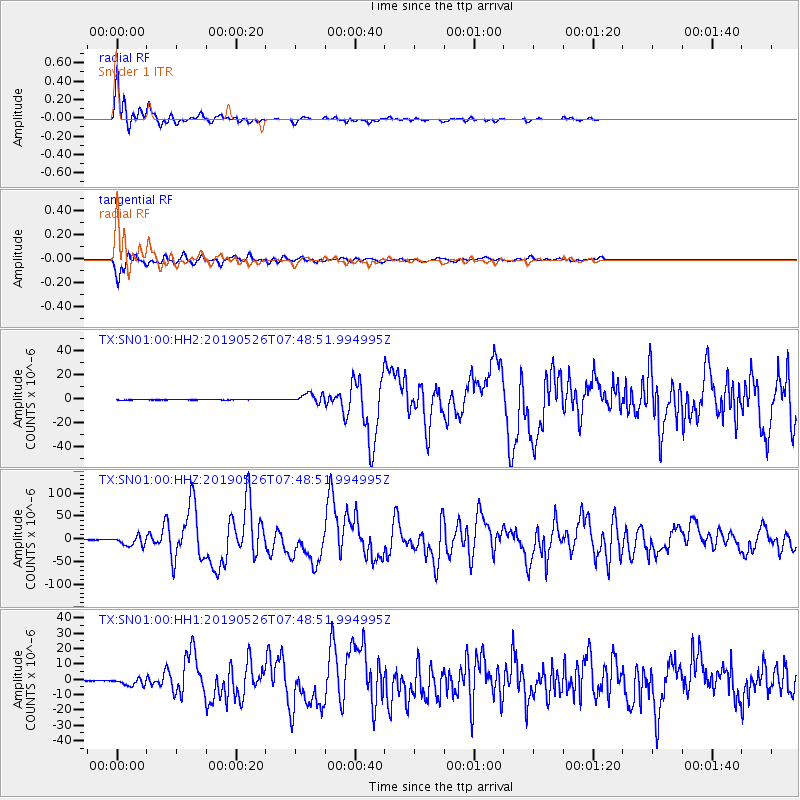
Signal To Noise
| Channel | StoN | STA | LTA |
| TX:SN01:00:HHZ:20190526T07:48:51.994995Z | 87.56141 | 1.0626804E-5 | 1.2136402E-7 |
| TX:SN01:00:HH1:20190526T07:48:51.994995Z | 14.173368 | 2.391841E-6 | 1.6875599E-7 |
| TX:SN01:00:HH2:20190526T07:48:51.994995Z | 26.882015 | 3.911942E-6 | 1.4552263E-7 |
| Arrivals |
| Ps | 5.4 SECOND |
| PpPs | 17 SECOND |
| PsPs/PpSs | 23 SECOND |


