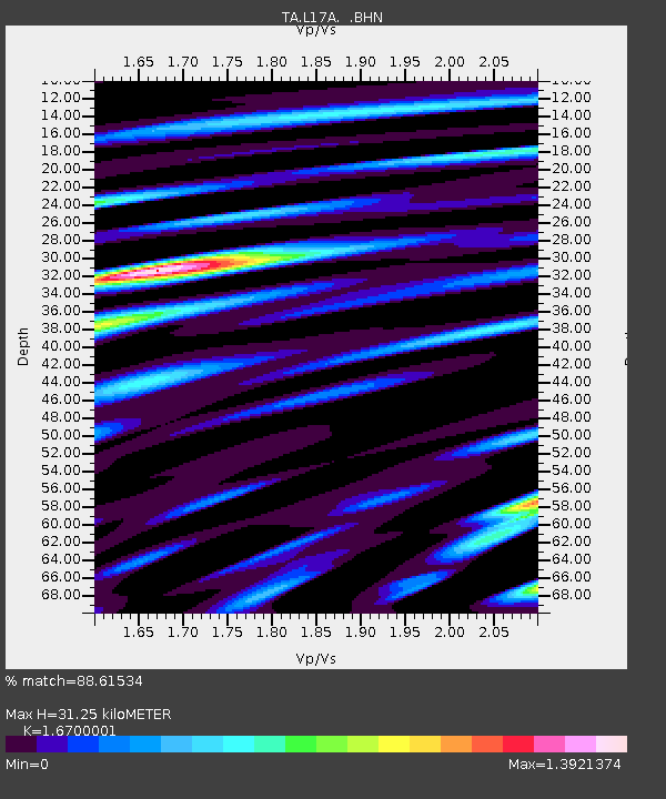
L17A Cokeville, WY, USA - Earthquake Result Viewer
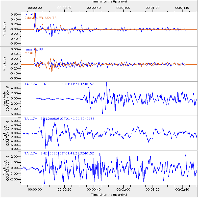
Earthquake location: Andreanof Islands, Aleutian Is.
Earthquake latitude/longitude: 51.9/-177.5
Earthquake time(UTC): 2008/05/02 (123) 01:33:37 GMT
Earthquake Depth: 14 km
Earthquake Magnitude: 6.3 MB, 6.8 MS, 6.6 MW, 6.6 MW
Earthquake Catalog/Contributor: WHDF/NEIC
Network: TA USArray Transportable Network (new EarthScope stations)
Station: L17A Cokeville, WY, USA
Lat/Lon: 42.10 N/110.87 W
Elevation: 1996 m
Distance: 45.0 deg
Az: 75.021 deg
Baz: 306.399 deg
Ray Param: 0.071544476
Estimated Moho Depth: 31.25 km
Estimated Crust Vp/Vs: 1.67
Assumed Crust Vp: 6.207 km/s
Estimated Crust Vs: 3.717 km/s
Estimated Crust Poisson's Ratio: 0.22
Radial Match: 88.61534 %
Radial Bump: 400
Transverse Match: 79.1822 %
Transverse Bump: 400
SOD ConfigId: 2504
Insert Time: 2010-03-06 23:00:55.630 +0000
GWidth: 2.5
Max Bumps: 400
Tol: 0.001

Signal To Noise

ChannelStoNSTALTA
TA:L17A: :BHN:20080502T01:41:21.324015Z8.5510751.1612254E-61.3579877E-7
TA:L17A: :BHE:20080502T01:41:21.324015Z2.14963363.650579E-71.6982332E-7
TA:L17A: :BHZ:20080502T01:41:21.324015Z3.24528364.7207644E-71.4546539E-7
Arrivals
Ps3.6 SECOND
PpPs13 SECOND
PsPs/PpSs16 SECOND