You are here: Home > Network List > TS - TERRAscope (Southern California Seismic Network) Stations List
> Station GLA Glamis, California, USA > Earthquake Result Viewer
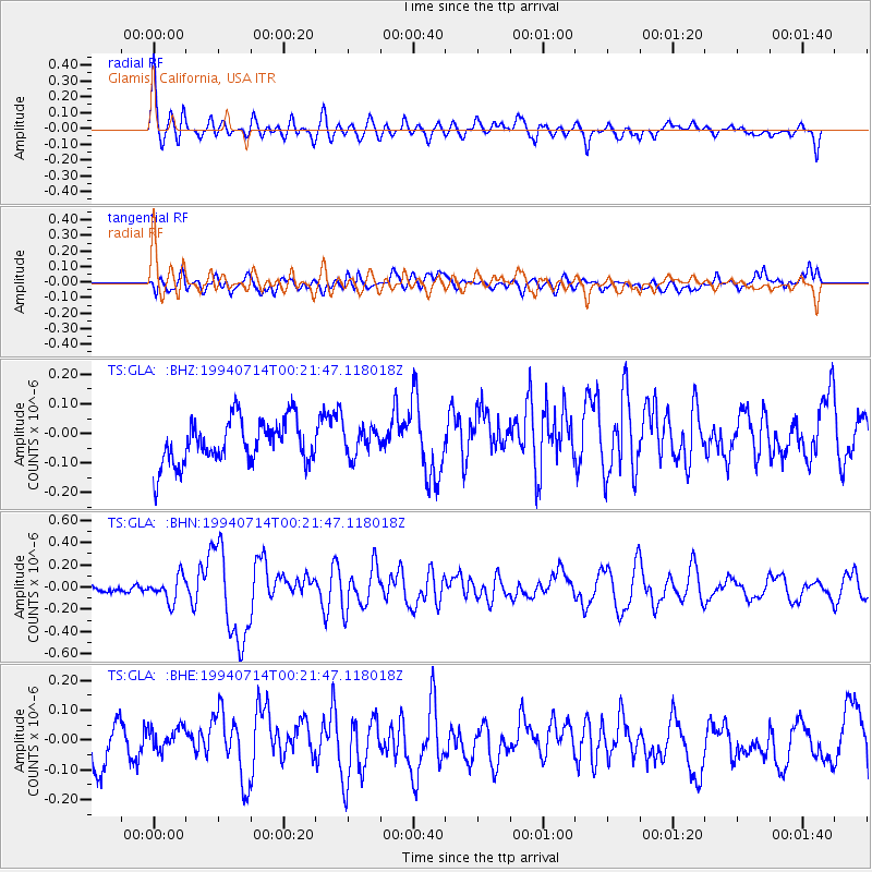
GLA Glamis, California, USA - Earthquake Result Viewer
*The percent match for this event was below the threshold and hence no stack was calculated.
| Earthquake location: |
Vanuatu Islands |
| Earthquake latitude/longitude: |
-16.5/167.4 |
| Earthquake time(UTC): |
1994/07/14 (195) 00:09:26 GMT |
| Earthquake Depth: |
33 km |
| Earthquake Magnitude: |
5.4 MB, 6.0 MS, 5.9 UNKNOWN, 6.1 MW |
| Earthquake Catalog/Contributor: |
WHDF/NEIC |
|
| Network: |
TS TERRAscope (Southern California Seismic Network) |
| Station: |
GLA Glamis, California, USA |
| Lat/Lon: |
33.05 N/114.83 W |
| Elevation: |
627 m |
|
| Distance: |
89.0 deg |
| Az: |
55.165 deg |
| Baz: |
249.611 deg |
| Ray Param: |
$rayparam |
*The percent match for this event was below the threshold and hence was not used in the summary stack. |
|
| Radial Match: |
70.08255 % |
| Radial Bump: |
400 |
| Transverse Match: |
55.057053 % |
| Transverse Bump: |
400 |
| SOD ConfigId: |
4480 |
| Insert Time: |
2010-02-26 14:14:21.266 +0000 |
| GWidth: |
2.5 |
| Max Bumps: |
400 |
| Tol: |
0.001 |
|
Signal To Noise
| Channel | StoN | STA | LTA |
| TS:GLA: :BHN:19940714T00:21:47.118018Z | 1.240474 | 1.10252685E-7 | 8.887948E-8 |
| TS:GLA: :BHE:19940714T00:21:47.118018Z | 0.83404094 | 5.3545765E-8 | 6.420041E-8 |
| TS:GLA: :BHZ:19940714T00:21:47.118018Z | 0.63608474 | 4.75384E-8 | 7.473596E-8 |
| Arrivals |
| Ps | |
| PpPs | |
| PsPs/PpSs | |


