You are here: Home > Network List > UU - University of Utah Regional Network Stations List
> Station MPU Maple Canyon, UT, USA > Earthquake Result Viewer
MPU Maple Canyon, UT, USA - Earthquake Result Viewer
| Earthquake location: |
Northern Peru |
| Earthquake latitude/longitude: |
-5.9/-75.3 |
| Earthquake time(UTC): |
2019/05/26 (146) 07:41:13 GMT |
| Earthquake Depth: |
105 km |
| Earthquake Magnitude: |
7.5 Mi |
| Earthquake Catalog/Contributor: |
NEIC PDE/at |
|
| Network: |
UU University of Utah Regional Network |
| Station: |
MPU Maple Canyon, UT, USA |
| Lat/Lon: |
40.02 N/111.63 W |
| Elevation: |
1909 m |
|
| Distance: |
56.6 deg |
| Az: |
326.986 deg |
| Baz: |
135.111 deg |
| Ray Param: |
0.06369908 |
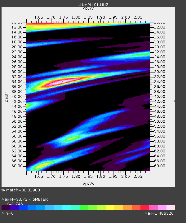
| Estimated Moho Depth: |
33.75 km |
| Estimated Crust Vp/Vs: |
1.75 |
| Assumed Crust Vp: |
6.155 km/s |
| Estimated Crust Vs: |
3.527 km/s |
| Estimated Crust Poisson's Ratio: |
0.26 |
|
| Radial Match: |
88.01988 % |
| Radial Bump: |
400 |
| Transverse Match: |
84.479416 % |
| Transverse Bump: |
400 |
| SOD ConfigId: |
18369291 |
| Insert Time: |
2019-06-09 07:54:30.837 +0000 |
| GWidth: |
2.5 |
| Max Bumps: |
400 |
| Tol: |
0.001 |
|

Signal To Noise
| Channel | StoN | STA | LTA |
| UU:MPU:01:HHZ:20190526T07:50:14.474976Z | 33.92354 | 2.0660889E-7 | 6.0904286E-9 |
| UU:MPU:01:HHN:20190526T07:50:14.474976Z | 24.14399 | 6.064478E-8 | 2.511796E-9 |
| UU:MPU:01:HHE:20190526T07:50:14.474976Z | 15.924728 | 7.017699E-8 | 4.406793E-9 |
| Arrivals |
| Ps | 4.3 SECOND |
| PpPs | 14 SECOND |
| PsPs/PpSs | 19 SECOND |


