You are here: Home > Network List > PF - Volcanologic Network of Piton de Fournaise-OVPF Stations List
> Station BON Bory Nord > Earthquake Result Viewer
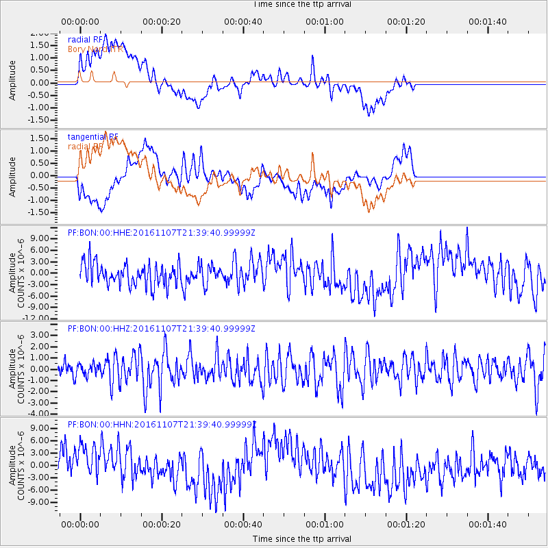
BON Bory Nord - Earthquake Result Viewer
*The percent match for this event was below the threshold and hence no stack was calculated.
| Earthquake location: |
Southwest Of Sumatra, Indonesia |
| Earthquake latitude/longitude: |
-8.1/104.8 |
| Earthquake time(UTC): |
2016/11/07 (312) 21:31:24 GMT |
| Earthquake Depth: |
10 km |
| Earthquake Magnitude: |
5.6 MWB |
| Earthquake Catalog/Contributor: |
NEIC PDE/NEIC COMCAT |
|
| Network: |
PF Volcanologic Network of Piton de Fournaise-OVPF |
| Station: |
BON Bory Nord |
| Lat/Lon: |
21.24 S/55.71 E |
| Elevation: |
2552 m |
|
| Distance: |
49.1 deg |
| Az: |
249.009 deg |
| Baz: |
82.236 deg |
| Ray Param: |
$rayparam |
*The percent match for this event was below the threshold and hence was not used in the summary stack. |
|
| Radial Match: |
53.520256 % |
| Radial Bump: |
400 |
| Transverse Match: |
34.170616 % |
| Transverse Bump: |
400 |
| SOD ConfigId: |
1858311 |
| Insert Time: |
2016-11-22 14:43:40.317 +0000 |
| GWidth: |
2.5 |
| Max Bumps: |
400 |
| Tol: |
0.001 |
|
Signal To Noise
| Channel | StoN | STA | LTA |
| PF:BON:00:HHZ:20161107T21:39:40.99999Z | 0.3276034 | 4.910584E-7 | 1.4989417E-6 |
| PF:BON:00:HHN:20161107T21:39:40.99999Z | 1.2091067 | 7.1250597E-6 | 5.89283E-6 |
| PF:BON:00:HHE:20161107T21:39:40.99999Z | 0.9085946 | 2.5559991E-6 | 2.8131349E-6 |
| Arrivals |
| Ps | |
| PpPs | |
| PsPs/PpSs | |


