You are here: Home > Network List > TA - USArray Transportable Network (new EarthScope stations) Stations List
> Station L17A Cokeville, WY, USA > Earthquake Result Viewer
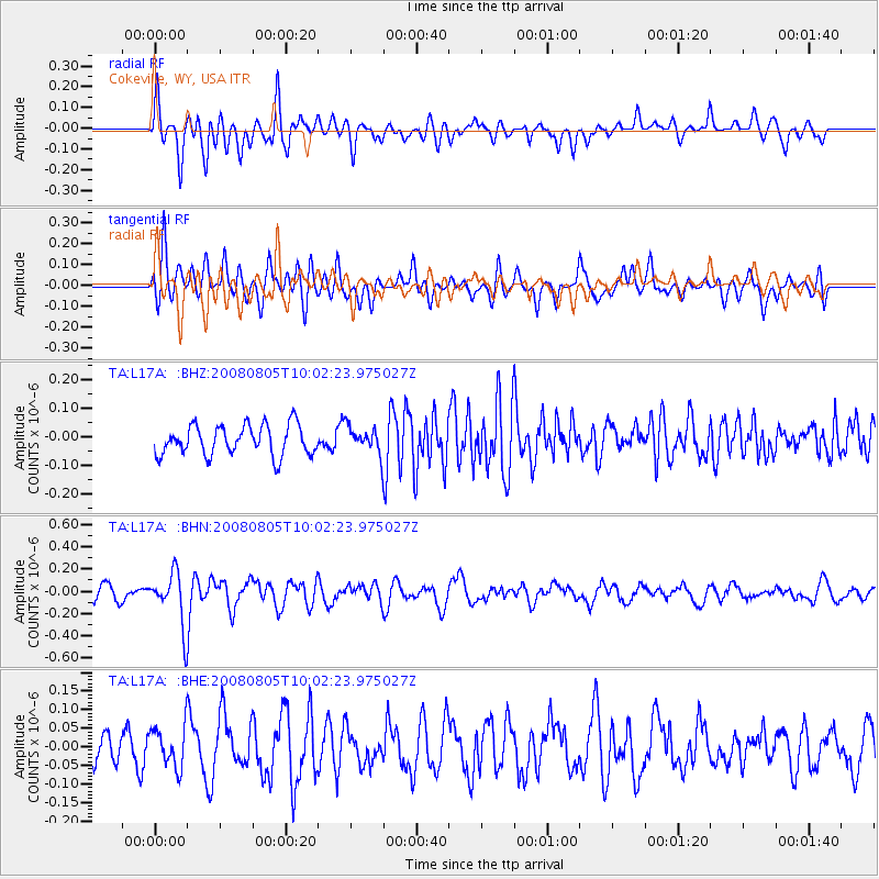
L17A Cokeville, WY, USA - Earthquake Result Viewer
*The percent match for this event was below the threshold and hence no stack was calculated.
| Earthquake location: |
Sichuan, China |
| Earthquake latitude/longitude: |
32.8/105.5 |
| Earthquake time(UTC): |
2008/08/05 (218) 09:49:17 GMT |
| Earthquake Depth: |
6.0 km |
| Earthquake Magnitude: |
5.9 MB, 6.0 MS, 6.0 MW, 5.9 MW |
| Earthquake Catalog/Contributor: |
WHDF/NEIC |
|
| Network: |
TA USArray Transportable Network (new EarthScope stations) |
| Station: |
L17A Cokeville, WY, USA |
| Lat/Lon: |
42.10 N/110.87 W |
| Elevation: |
1996 m |
|
| Distance: |
98.4 deg |
| Az: |
26.488 deg |
| Baz: |
329.669 deg |
| Ray Param: |
$rayparam |
*The percent match for this event was below the threshold and hence was not used in the summary stack. |
|
| Radial Match: |
58.53732 % |
| Radial Bump: |
400 |
| Transverse Match: |
63.09072 % |
| Transverse Bump: |
400 |
| SOD ConfigId: |
2504 |
| Insert Time: |
2010-03-06 23:01:31.505 +0000 |
| GWidth: |
2.5 |
| Max Bumps: |
400 |
| Tol: |
0.001 |
|
Signal To Noise
| Channel | StoN | STA | LTA |
| TA:L17A: :BHN:20080805T10:02:23.975027Z | 3.8193834 | 2.3455948E-7 | 6.141292E-8 |
| TA:L17A: :BHE:20080805T10:02:23.975027Z | 1.1398768 | 5.4058873E-8 | 4.742519E-8 |
| TA:L17A: :BHZ:20080805T10:02:23.975027Z | 0.88749427 | 4.632902E-8 | 5.220205E-8 |
| Arrivals |
| Ps | |
| PpPs | |
| PsPs/PpSs | |


