You are here: Home > Network List > TA - USArray Transportable Network (new EarthScope stations) Stations List
> Station L17A Cokeville, WY, USA > Earthquake Result Viewer
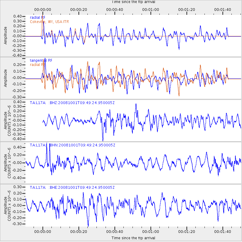
L17A Cokeville, WY, USA - Earthquake Result Viewer
*The percent match for this event was below the threshold and hence no stack was calculated.
| Earthquake location: |
Southeast Of Honshu, Japan |
| Earthquake latitude/longitude: |
30.2/138.8 |
| Earthquake time(UTC): |
2008/10/01 (275) 09:38:12 GMT |
| Earthquake Depth: |
414 km |
| Earthquake Magnitude: |
5.7 MW, 5.1 MB, 5.7 MW |
| Earthquake Catalog/Contributor: |
WHDF/NEIC |
|
| Network: |
TA USArray Transportable Network (new EarthScope stations) |
| Station: |
L17A Cokeville, WY, USA |
| Lat/Lon: |
42.10 N/110.87 W |
| Elevation: |
1996 m |
|
| Distance: |
83.7 deg |
| Az: |
44.59 deg |
| Baz: |
305.22 deg |
| Ray Param: |
$rayparam |
*The percent match for this event was below the threshold and hence was not used in the summary stack. |
|
| Radial Match: |
61.872322 % |
| Radial Bump: |
400 |
| Transverse Match: |
48.12481 % |
| Transverse Bump: |
400 |
| SOD ConfigId: |
2556 |
| Insert Time: |
2010-03-06 23:01:34.964 +0000 |
| GWidth: |
2.5 |
| Max Bumps: |
400 |
| Tol: |
0.001 |
|
Signal To Noise
| Channel | StoN | STA | LTA |
| TA:L17A: :BHN:20081001T09:49:24.950005Z | 1.9376571 | 1.8463557E-7 | 9.528805E-8 |
| TA:L17A: :BHE:20081001T09:49:24.950005Z | 0.8954897 | 5.7475532E-8 | 6.4183354E-8 |
| TA:L17A: :BHZ:20081001T09:49:24.950005Z | 2.4003603 | 1.6572238E-7 | 6.9040624E-8 |
| Arrivals |
| Ps | |
| PpPs | |
| PsPs/PpSs | |


