You are here: Home > Network List > WY - Yellowstone Wyoming Seismic Network Stations List
> Station YDD Grant Village, YNP, WY, USA old TA-H17A > Earthquake Result Viewer
YDD Grant Village, YNP, WY, USA old TA-H17A - Earthquake Result Viewer
| Earthquake location: |
Northern Peru |
| Earthquake latitude/longitude: |
-5.9/-75.3 |
| Earthquake time(UTC): |
2019/05/26 (146) 07:41:13 GMT |
| Earthquake Depth: |
105 km |
| Earthquake Magnitude: |
7.5 Mi |
| Earthquake Catalog/Contributor: |
NEIC PDE/at |
|
| Network: |
WY Yellowstone Wyoming Seismic Network |
| Station: |
YDD Grant Village, YNP, WY, USA old TA-H17A |
| Lat/Lon: |
44.40 N/110.58 W |
| Elevation: |
2400 m |
|
| Distance: |
59.3 deg |
| Az: |
331.208 deg |
| Baz: |
138.061 deg |
| Ray Param: |
0.06199202 |
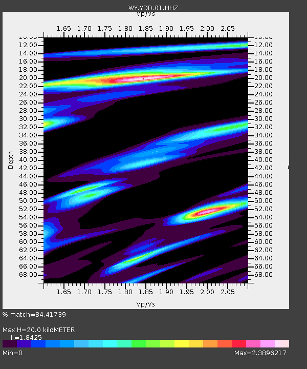
| Estimated Moho Depth: |
20.0 km |
| Estimated Crust Vp/Vs: |
1.84 |
| Assumed Crust Vp: |
6.35 km/s |
| Estimated Crust Vs: |
3.446 km/s |
| Estimated Crust Poisson's Ratio: |
0.29 |
|
| Radial Match: |
84.41739 % |
| Radial Bump: |
400 |
| Transverse Match: |
95.1433 % |
| Transverse Bump: |
400 |
| SOD ConfigId: |
18369291 |
| Insert Time: |
2019-06-09 07:55:15.661 +0000 |
| GWidth: |
2.5 |
| Max Bumps: |
400 |
| Tol: |
0.001 |
|

Signal To Noise
| Channel | StoN | STA | LTA |
| WY:YDD:01:HHZ:20190526T07:50:32.869995Z | 21.285418 | 2.722024E-7 | 1.2788212E-8 |
| WY:YDD:01:HHN:20190526T07:50:32.869995Z | 14.479366 | 1.2326507E-7 | 8.513154E-9 |
| WY:YDD:01:HHE:20190526T07:50:32.869995Z | 10.818776 | 9.214957E-8 | 8.517559E-9 |
| Arrivals |
| Ps | 2.8 SECOND |
| PpPs | 8.6 SECOND |
| PsPs/PpSs | 11 SECOND |


