You are here: Home > Network List > WY - Yellowstone Wyoming Seismic Network Stations List
> Station YMR Madison River, YNP, WY, USA > Earthquake Result Viewer
YMR Madison River, YNP, WY, USA - Earthquake Result Viewer
| Earthquake location: |
Northern Peru |
| Earthquake latitude/longitude: |
-5.9/-75.3 |
| Earthquake time(UTC): |
2019/05/26 (146) 07:41:13 GMT |
| Earthquake Depth: |
105 km |
| Earthquake Magnitude: |
7.5 Mi |
| Earthquake Catalog/Contributor: |
NEIC PDE/at |
|
| Network: |
WY Yellowstone Wyoming Seismic Network |
| Station: |
YMR Madison River, YNP, WY, USA |
| Lat/Lon: |
44.67 N/110.96 W |
| Elevation: |
2149 m |
|
| Distance: |
59.7 deg |
| Az: |
331.181 deg |
| Baz: |
137.775 deg |
| Ray Param: |
0.06173964 |
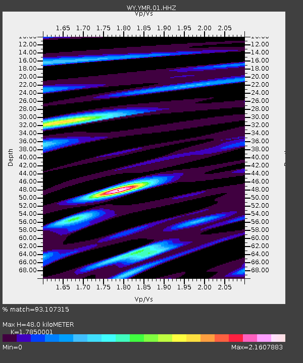
| Estimated Moho Depth: |
48.0 km |
| Estimated Crust Vp/Vs: |
1.79 |
| Assumed Crust Vp: |
6.35 km/s |
| Estimated Crust Vs: |
3.557 km/s |
| Estimated Crust Poisson's Ratio: |
0.27 |
|
| Radial Match: |
93.107315 % |
| Radial Bump: |
400 |
| Transverse Match: |
85.0764 % |
| Transverse Bump: |
400 |
| SOD ConfigId: |
18369291 |
| Insert Time: |
2019-06-09 07:55:19.801 +0000 |
| GWidth: |
2.5 |
| Max Bumps: |
400 |
| Tol: |
0.001 |
|

Signal To Noise
| Channel | StoN | STA | LTA |
| WY:YMR:01:HHZ:20190526T07:50:35.538025Z | 17.337877 | 2.9939872E-7 | 1.7268476E-8 |
| WY:YMR:01:HHN:20190526T07:50:35.538025Z | 10.350696 | 1.1245771E-7 | 1.0864749E-8 |
| WY:YMR:01:HHE:20190526T07:50:35.538025Z | 14.730723 | 1.191841E-7 | 8.090852E-9 |
| Arrivals |
| Ps | 6.2 SECOND |
| PpPs | 20 SECOND |
| PsPs/PpSs | 26 SECOND |


