You are here: Home > Network List > TA - USArray Transportable Network (new EarthScope stations) Stations List
> Station L17A Cokeville, WY, USA > Earthquake Result Viewer
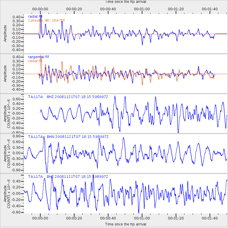
L17A Cokeville, WY, USA - Earthquake Result Viewer
*The percent match for this event was below the threshold and hence no stack was calculated.
| Earthquake location: |
Solomon Islands |
| Earthquake latitude/longitude: |
-8.9/159.6 |
| Earthquake time(UTC): |
2008/11/21 (326) 07:05:34 GMT |
| Earthquake Depth: |
118 km |
| Earthquake Magnitude: |
6.0 MB, 6.1 MW, 6.0 MW |
| Earthquake Catalog/Contributor: |
WHDF/NEIC |
|
| Network: |
TA USArray Transportable Network (new EarthScope stations) |
| Station: |
L17A Cokeville, WY, USA |
| Lat/Lon: |
42.10 N/110.87 W |
| Elevation: |
1996 m |
|
| Distance: |
95.6 deg |
| Az: |
48.398 deg |
| Baz: |
263.081 deg |
| Ray Param: |
$rayparam |
*The percent match for this event was below the threshold and hence was not used in the summary stack. |
|
| Radial Match: |
61.229053 % |
| Radial Bump: |
400 |
| Transverse Match: |
46.397953 % |
| Transverse Bump: |
400 |
| SOD ConfigId: |
2658 |
| Insert Time: |
2010-03-06 23:01:49.476 +0000 |
| GWidth: |
2.5 |
| Max Bumps: |
400 |
| Tol: |
0.001 |
|
Signal To Noise
| Channel | StoN | STA | LTA |
| TA:L17A: :BHN:20081121T07:18:15.598997Z | 2.3361232 | 5.113862E-7 | 2.1890376E-7 |
| TA:L17A: :BHE:20081121T07:18:15.598997Z | 1.3357712 | 2.6302607E-7 | 1.9690951E-7 |
| TA:L17A: :BHZ:20081121T07:18:15.598997Z | 1.0192053 | 1.8574923E-7 | 1.8224908E-7 |
| Arrivals |
| Ps | |
| PpPs | |
| PsPs/PpSs | |


