You are here: Home > Network List > YO16 - Yukon Observatory Stations List
> Station KOTA YGS, Kotaneelee Airstrip, YK > Earthquake Result Viewer
KOTA YGS, Kotaneelee Airstrip, YK - Earthquake Result Viewer
| Earthquake location: |
Northern Peru |
| Earthquake latitude/longitude: |
-5.9/-75.3 |
| Earthquake time(UTC): |
2019/05/26 (146) 07:41:13 GMT |
| Earthquake Depth: |
105 km |
| Earthquake Magnitude: |
7.5 Mi |
| Earthquake Catalog/Contributor: |
NEIC PDE/at |
|
| Network: |
YO Yukon Observatory |
| Station: |
KOTA YGS, Kotaneelee Airstrip, YK |
| Lat/Lon: |
60.13 N/124.05 W |
| Elevation: |
386 m |
|
| Distance: |
76.1 deg |
| Az: |
337.19 deg |
| Baz: |
129.607 deg |
| Ray Param: |
0.05096241 |
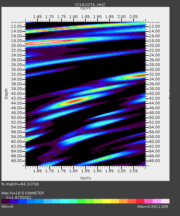
| Estimated Moho Depth: |
18.5 km |
| Estimated Crust Vp/Vs: |
1.67 |
| Assumed Crust Vp: |
6.419 km/s |
| Estimated Crust Vs: |
3.844 km/s |
| Estimated Crust Poisson's Ratio: |
0.22 |
|
| Radial Match: |
94.33706 % |
| Radial Bump: |
400 |
| Transverse Match: |
78.92663 % |
| Transverse Bump: |
400 |
| SOD ConfigId: |
18369291 |
| Insert Time: |
2019-06-09 07:55:36.242 +0000 |
| GWidth: |
2.5 |
| Max Bumps: |
400 |
| Tol: |
0.001 |
|

Signal To Noise
| Channel | StoN | STA | LTA |
| YO:KOTA: :HHZ:20190526T07:52:18.369995Z | 19.85211 | 1.1251157E-5 | 5.6674867E-7 |
| YO:KOTA: :HHN:20190526T07:52:18.369995Z | 15.395195 | 3.2520272E-6 | 2.1123651E-7 |
| YO:KOTA: :HHE:20190526T07:52:18.369995Z | 16.13927 | 4.109384E-6 | 2.5462018E-7 |
| Arrivals |
| Ps | 2.0 SECOND |
| PpPs | 7.4 SECOND |
| PsPs/PpSs | 9.4 SECOND |


