You are here: Home > Network List > TA - USArray Transportable Network (new EarthScope stations) Stations List
> Station L17A Cokeville, WY, USA > Earthquake Result Viewer
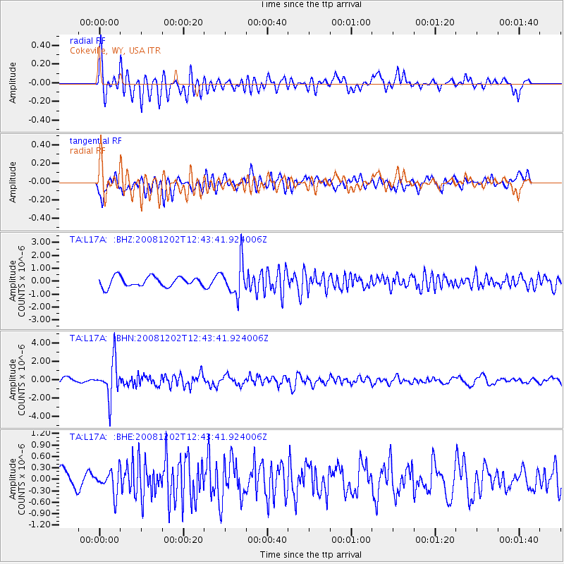
L17A Cokeville, WY, USA - Earthquake Result Viewer
*The percent match for this event was below the threshold and hence no stack was calculated.
| Earthquake location: |
Mariana Islands |
| Earthquake latitude/longitude: |
19.1/145.8 |
| Earthquake time(UTC): |
2008/12/02 (337) 12:31:43 GMT |
| Earthquake Depth: |
137 km |
| Earthquake Magnitude: |
5.9 MB, 5.9 MW, 5.9 MW |
| Earthquake Catalog/Contributor: |
WHDF/NEIC |
|
| Network: |
TA USArray Transportable Network (new EarthScope stations) |
| Station: |
L17A Cokeville, WY, USA |
| Lat/Lon: |
42.10 N/110.87 W |
| Elevation: |
1996 m |
|
| Distance: |
86.9 deg |
| Az: |
46.477 deg |
| Baz: |
292.884 deg |
| Ray Param: |
$rayparam |
*The percent match for this event was below the threshold and hence was not used in the summary stack. |
|
| Radial Match: |
68.0068 % |
| Radial Bump: |
400 |
| Transverse Match: |
70.253716 % |
| Transverse Bump: |
400 |
| SOD ConfigId: |
2658 |
| Insert Time: |
2010-03-06 23:01:56.135 +0000 |
| GWidth: |
2.5 |
| Max Bumps: |
400 |
| Tol: |
0.001 |
|
Signal To Noise
| Channel | StoN | STA | LTA |
| TA:L17A: :BHN:20081202T12:43:41.924006Z | 7.326977 | 2.0207633E-6 | 2.757977E-7 |
| TA:L17A: :BHE:20081202T12:43:41.924006Z | 1.2624298 | 3.1241413E-7 | 2.474705E-7 |
| TA:L17A: :BHZ:20081202T12:43:41.924006Z | 3.4228137 | 1.2968319E-6 | 3.7887892E-7 |
| Arrivals |
| Ps | |
| PpPs | |
| PsPs/PpSs | |


