You are here: Home > Network List > TA - USArray Transportable Network (new EarthScope stations) Stations List
> Station G31M Satah River, YT, CAN > Earthquake Result Viewer
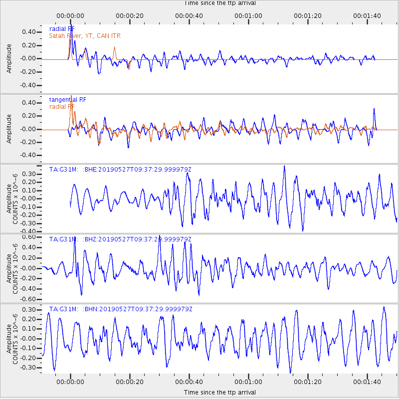
G31M Satah River, YT, CAN - Earthquake Result Viewer
*The percent match for this event was below the threshold and hence no stack was calculated.
| Earthquake location: |
Solomon Islands |
| Earthquake latitude/longitude: |
-8.2/158.6 |
| Earthquake time(UTC): |
2019/05/27 (147) 09:25:20 GMT |
| Earthquake Depth: |
117 km |
| Earthquake Magnitude: |
5.5 mb |
| Earthquake Catalog/Contributor: |
NEIC PDE/us |
|
| Network: |
TA USArray Transportable Network (new EarthScope stations) |
| Station: |
G31M Satah River, YT, CAN |
| Lat/Lon: |
66.92 N/134.27 W |
| Elevation: |
61 m |
|
| Distance: |
88.8 deg |
| Az: |
21.3 deg |
| Baz: |
245.807 deg |
| Ray Param: |
$rayparam |
*The percent match for this event was below the threshold and hence was not used in the summary stack. |
|
| Radial Match: |
74.90332 % |
| Radial Bump: |
400 |
| Transverse Match: |
48.530136 % |
| Transverse Bump: |
400 |
| SOD ConfigId: |
18369291 |
| Insert Time: |
2019-06-10 09:29:04.384 +0000 |
| GWidth: |
2.5 |
| Max Bumps: |
400 |
| Tol: |
0.001 |
|
Signal To Noise
| Channel | StoN | STA | LTA |
| TA:G31M: :BHZ:20190527T09:37:29.999979Z | 2.8508127 | 2.6252465E-7 | 9.208766E-8 |
| TA:G31M: :BHN:20190527T09:37:29.999979Z | 0.7558211 | 1.2792869E-7 | 1.6925789E-7 |
| TA:G31M: :BHE:20190527T09:37:29.999979Z | 1.0462029 | 8.943407E-8 | 8.548444E-8 |
| Arrivals |
| Ps | |
| PpPs | |
| PsPs/PpSs | |


