You are here: Home > Network List > TA - USArray Transportable Network (new EarthScope stations) Stations List
> Station K15K Wolf Creek Mountain, AK, USA > Earthquake Result Viewer
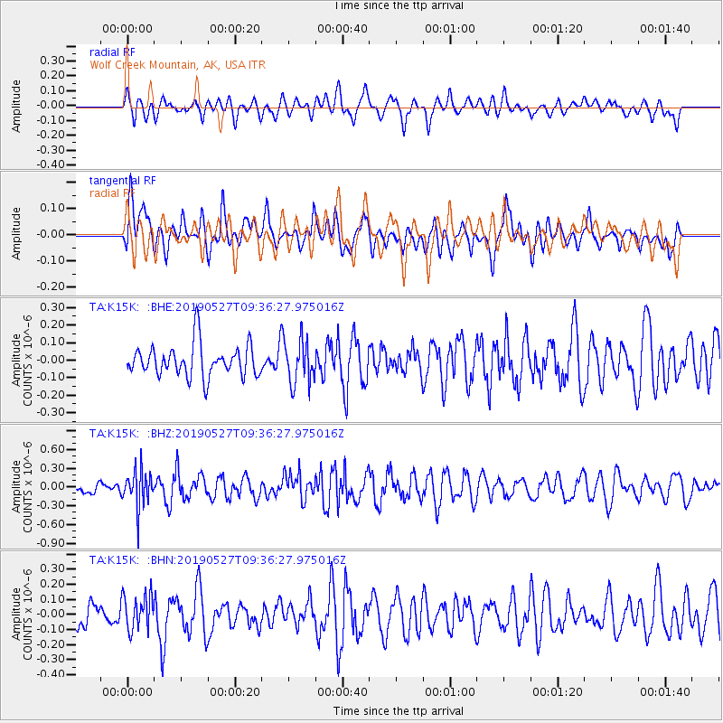
K15K Wolf Creek Mountain, AK, USA - Earthquake Result Viewer
*The percent match for this event was below the threshold and hence no stack was calculated.
| Earthquake location: |
Solomon Islands |
| Earthquake latitude/longitude: |
-8.2/158.6 |
| Earthquake time(UTC): |
2019/05/27 (147) 09:25:20 GMT |
| Earthquake Depth: |
117 km |
| Earthquake Magnitude: |
5.5 mb |
| Earthquake Catalog/Contributor: |
NEIC PDE/us |
|
| Network: |
TA USArray Transportable Network (new EarthScope stations) |
| Station: |
K15K Wolf Creek Mountain, AK, USA |
| Lat/Lon: |
62.29 N/161.53 W |
| Elevation: |
346 m |
|
| Distance: |
76.7 deg |
| Az: |
17.924 deg |
| Baz: |
220.677 deg |
| Ray Param: |
$rayparam |
*The percent match for this event was below the threshold and hence was not used in the summary stack. |
|
| Radial Match: |
50.8722 % |
| Radial Bump: |
400 |
| Transverse Match: |
56.651672 % |
| Transverse Bump: |
400 |
| SOD ConfigId: |
18369291 |
| Insert Time: |
2019-06-10 09:29:14.235 +0000 |
| GWidth: |
2.5 |
| Max Bumps: |
400 |
| Tol: |
0.001 |
|
Signal To Noise
| Channel | StoN | STA | LTA |
| TA:K15K: :BHZ:20190527T09:36:27.975016Z | 2.610904 | 2.914623E-7 | 1.11632716E-7 |
| TA:K15K: :BHN:20190527T09:36:27.975016Z | 1.055627 | 1.1569099E-7 | 1.0959457E-7 |
| TA:K15K: :BHE:20190527T09:36:27.975016Z | 1.3564734 | 1.2371578E-7 | 9.120398E-8 |
| Arrivals |
| Ps | |
| PpPs | |
| PsPs/PpSs | |


