You are here: Home > Network List > TA - USArray Transportable Network (new EarthScope stations) Stations List
> Station L17A Cokeville, WY, USA > Earthquake Result Viewer
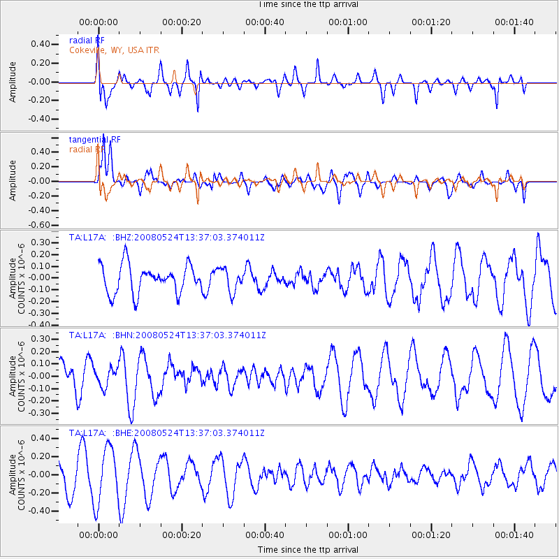
L17A Cokeville, WY, USA - Earthquake Result Viewer
*The percent match for this event was below the threshold and hence no stack was calculated.
| Earthquake location: |
Solomon Islands |
| Earthquake latitude/longitude: |
-7.2/156.1 |
| Earthquake time(UTC): |
2008/05/24 (145) 13:24:05 GMT |
| Earthquake Depth: |
29 km |
| Earthquake Magnitude: |
5.8 MB, 5.5 MS, 5.9 MW, 5.8 MW |
| Earthquake Catalog/Contributor: |
WHDF/NEIC |
|
| Network: |
TA USArray Transportable Network (new EarthScope stations) |
| Station: |
L17A Cokeville, WY, USA |
| Lat/Lon: |
42.10 N/110.87 W |
| Elevation: |
1996 m |
|
| Distance: |
97.0 deg |
| Az: |
48.485 deg |
| Baz: |
266.704 deg |
| Ray Param: |
$rayparam |
*The percent match for this event was below the threshold and hence was not used in the summary stack. |
|
| Radial Match: |
73.853546 % |
| Radial Bump: |
319 |
| Transverse Match: |
59.55135 % |
| Transverse Bump: |
354 |
| SOD ConfigId: |
2504 |
| Insert Time: |
2010-03-06 23:02:23.542 +0000 |
| GWidth: |
2.5 |
| Max Bumps: |
400 |
| Tol: |
0.001 |
|
Signal To Noise
| Channel | StoN | STA | LTA |
| TA:L17A: :BHN:20080524T13:37:03.374011Z | 0.50593203 | 7.510729E-8 | 1.4845332E-7 |
| TA:L17A: :BHE:20080524T13:37:03.374011Z | 2.1066844 | 3.0948064E-7 | 1.4690413E-7 |
| TA:L17A: :BHZ:20080524T13:37:03.374011Z | 0.82813895 | 9.910716E-8 | 1.1967455E-7 |
| Arrivals |
| Ps | |
| PpPs | |
| PsPs/PpSs | |


