You are here: Home > Network List > TA - USArray Transportable Network (new EarthScope stations) Stations List
> Station L17A Cokeville, WY, USA > Earthquake Result Viewer
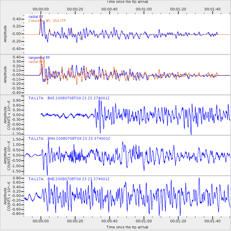
L17A Cokeville, WY, USA - Earthquake Result Viewer
*The percent match for this event was below the threshold and hence no stack was calculated.
| Earthquake location: |
Southern Peru |
| Earthquake latitude/longitude: |
-16.0/-71.7 |
| Earthquake time(UTC): |
2008/07/08 (190) 09:13:07 GMT |
| Earthquake Depth: |
123 km |
| Earthquake Magnitude: |
5.8 MB, 6.2 MW, 6.2 MW |
| Earthquake Catalog/Contributor: |
WHDF/NEIC |
|
| Network: |
TA USArray Transportable Network (new EarthScope stations) |
| Station: |
L17A Cokeville, WY, USA |
| Lat/Lon: |
42.10 N/110.87 W |
| Elevation: |
1996 m |
|
| Distance: |
68.1 deg |
| Az: |
329.601 deg |
| Baz: |
139.158 deg |
| Ray Param: |
$rayparam |
*The percent match for this event was below the threshold and hence was not used in the summary stack. |
|
| Radial Match: |
75.82803 % |
| Radial Bump: |
400 |
| Transverse Match: |
81.60041 % |
| Transverse Bump: |
400 |
| SOD ConfigId: |
2504 |
| Insert Time: |
2010-03-06 23:02:31.000 +0000 |
| GWidth: |
2.5 |
| Max Bumps: |
400 |
| Tol: |
0.001 |
|
Signal To Noise
| Channel | StoN | STA | LTA |
| TA:L17A: :BHN:20080708T09:23:23.374001Z | 8.803459 | 7.1295676E-7 | 8.098598E-8 |
| TA:L17A: :BHE:20080708T09:23:23.374001Z | 3.6870391 | 2.8885808E-7 | 7.8344186E-8 |
| TA:L17A: :BHZ:20080708T09:23:23.374001Z | 5.848812 | 4.2119058E-7 | 7.2013016E-8 |
| Arrivals |
| Ps | |
| PpPs | |
| PsPs/PpSs | |


