You are here: Home > Network List > TA - USArray Transportable Network (new EarthScope stations) Stations List
> Station L17A Cokeville, WY, USA > Earthquake Result Viewer
L17A Cokeville, WY, USA - Earthquake Result Viewer
*The percent match for this event was below the threshold and hence no stack was calculated.
| Earthquake location: |
Guatemala |
| Earthquake latitude/longitude: |
14.6/-91.2 |
| Earthquake time(UTC): |
2009/05/03 (123) 16:21:47 GMT |
| Earthquake Depth: |
124 km |
| Earthquake Magnitude: |
5.6 MB, 6.2 MW, 6.2 MW |
| Earthquake Catalog/Contributor: |
WHDF/NEIC |
|
| Network: |
TA USArray Transportable Network (new EarthScope stations) |
| Station: |
L17A Cokeville, WY, USA |
| Lat/Lon: |
42.10 N/110.87 W |
| Elevation: |
1996 m |
|
| Distance: |
32.3 deg |
| Az: |
331.983 deg |
| Baz: |
142.328 deg |
| Ray Param: |
$rayparam |
*The percent match for this event was below the threshold and hence was not used in the summary stack. |
|
| Radial Match: |
79.4608 % |
| Radial Bump: |
400 |
| Transverse Match: |
73.80785 % |
| Transverse Bump: |
400 |
| SOD ConfigId: |
2658 |
| Insert Time: |
2010-03-06 23:02:35.028 +0000 |
| GWidth: |
2.5 |
| Max Bumps: |
400 |
| Tol: |
0.001 |
|
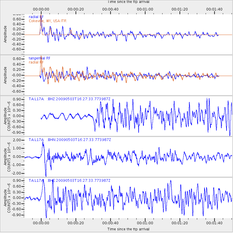
Signal To Noise
| Channel | StoN | STA | LTA |
| TA:L17A: :BHN:20090503T16:27:33.773987Z | 12.590262 | 9.970338E-7 | 7.919086E-8 |
| TA:L17A: :BHE:20090503T16:27:33.773987Z | 9.4454775 | 5.343706E-7 | 5.6574223E-8 |
| TA:L17A: :BHZ:20090503T16:27:33.773987Z | 3.941689 | 3.9802825E-7 | 1.0097911E-7 |
| Arrivals |
| Ps | |
| PpPs | |
| PsPs/PpSs | |


