You are here: Home > Network List > TA - USArray Transportable Network (new EarthScope stations) Stations List
> Station L17A Cokeville, WY, USA > Earthquake Result Viewer
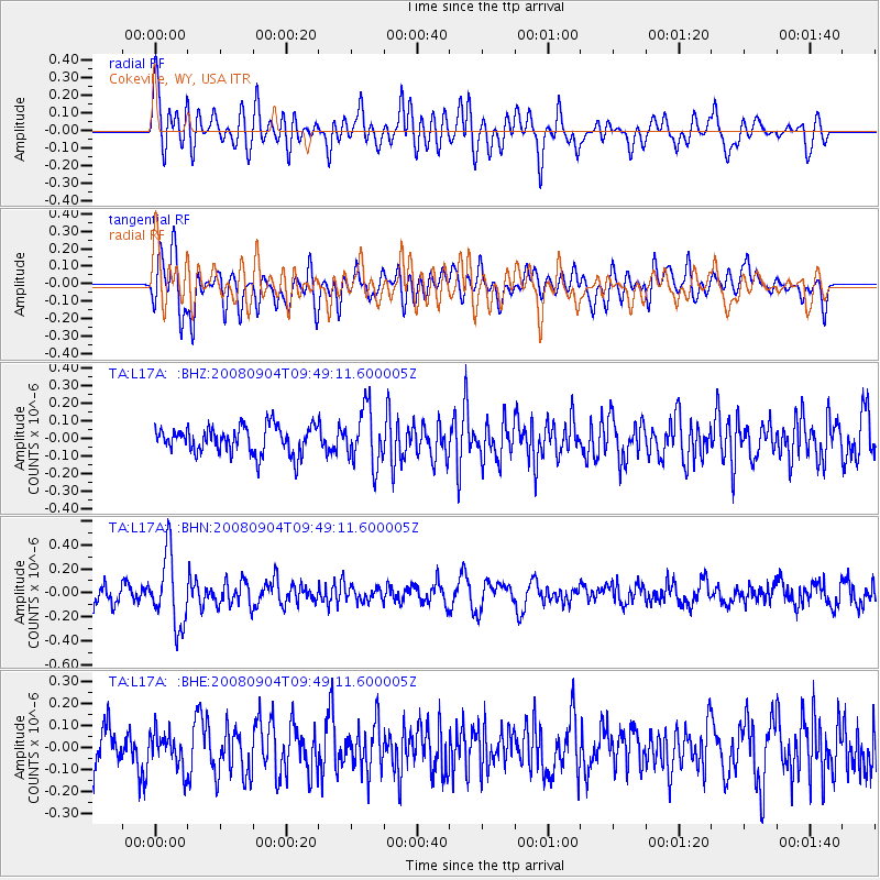
L17A Cokeville, WY, USA - Earthquake Result Viewer
*The percent match for this event was below the threshold and hence no stack was calculated.
| Earthquake location: |
Santa Cruz Islands |
| Earthquake latitude/longitude: |
-12.1/167.1 |
| Earthquake time(UTC): |
2008/09/04 (248) 09:37:03 GMT |
| Earthquake Depth: |
272 km |
| Earthquake Magnitude: |
5.5 MB, 5.7 MW, 5.6 MW |
| Earthquake Catalog/Contributor: |
WHDF/NEIC |
|
| Network: |
TA USArray Transportable Network (new EarthScope stations) |
| Station: |
L17A Cokeville, WY, USA |
| Lat/Lon: |
42.10 N/110.87 W |
| Elevation: |
1996 m |
|
| Distance: |
92.2 deg |
| Az: |
47.525 deg |
| Baz: |
255.739 deg |
| Ray Param: |
$rayparam |
*The percent match for this event was below the threshold and hence was not used in the summary stack. |
|
| Radial Match: |
58.469524 % |
| Radial Bump: |
400 |
| Transverse Match: |
62.09017 % |
| Transverse Bump: |
400 |
| SOD ConfigId: |
2504 |
| Insert Time: |
2010-03-06 23:02:42.332 +0000 |
| GWidth: |
2.5 |
| Max Bumps: |
400 |
| Tol: |
0.001 |
|
Signal To Noise
| Channel | StoN | STA | LTA |
| TA:L17A: :BHN:20080904T09:49:11.600005Z | 3.6978335 | 2.9185148E-7 | 7.892499E-8 |
| TA:L17A: :BHE:20080904T09:49:11.600005Z | 0.93809295 | 8.056481E-8 | 8.5881474E-8 |
| TA:L17A: :BHZ:20080904T09:49:11.600005Z | 2.0462465 | 1.5734105E-7 | 7.6892526E-8 |
| Arrivals |
| Ps | |
| PpPs | |
| PsPs/PpSs | |


