You are here: Home > Network List > TA - USArray Transportable Network (new EarthScope stations) Stations List
> Station L17A Cokeville, WY, USA > Earthquake Result Viewer
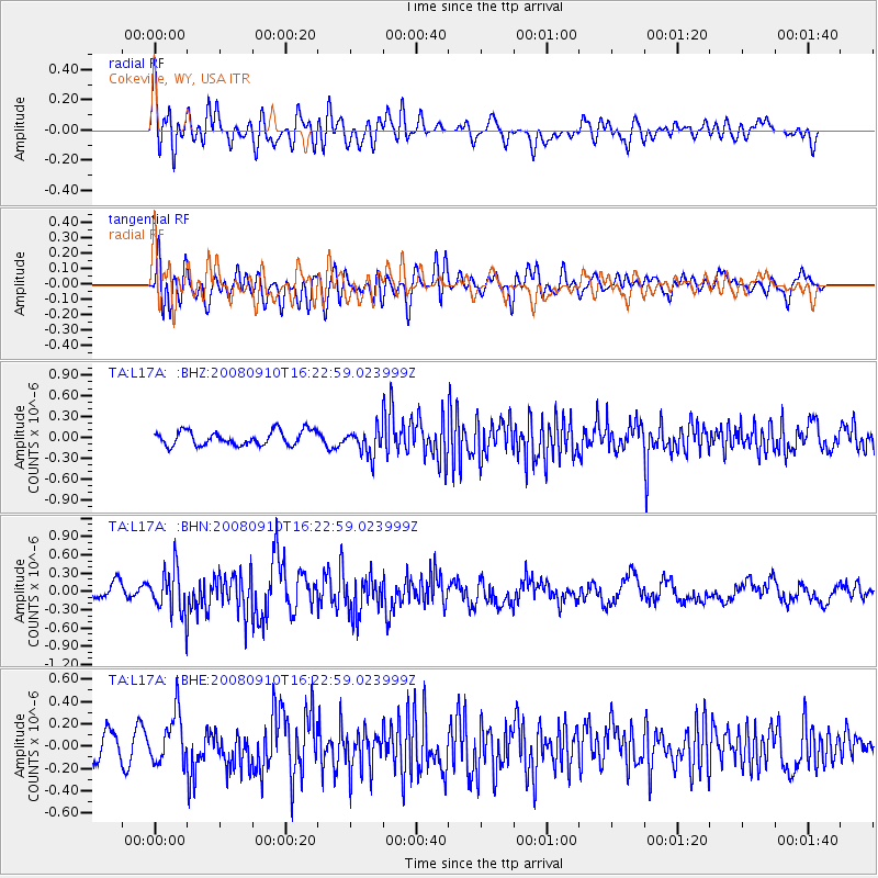
L17A Cokeville, WY, USA - Earthquake Result Viewer
*The percent match for this event was below the threshold and hence no stack was calculated.
| Earthquake location: |
Northern Chile |
| Earthquake latitude/longitude: |
-20.3/-69.2 |
| Earthquake time(UTC): |
2008/09/10 (254) 16:12:04 GMT |
| Earthquake Depth: |
38 km |
| Earthquake Magnitude: |
5.6 MB, 5.3 MS |
| Earthquake Catalog/Contributor: |
WHDF/NEIC |
|
| Network: |
TA USArray Transportable Network (new EarthScope stations) |
| Station: |
L17A Cokeville, WY, USA |
| Lat/Lon: |
42.10 N/110.87 W |
| Elevation: |
1996 m |
|
| Distance: |
73.0 deg |
| Az: |
328.859 deg |
| Baz: |
139.277 deg |
| Ray Param: |
$rayparam |
*The percent match for this event was below the threshold and hence was not used in the summary stack. |
|
| Radial Match: |
54.951286 % |
| Radial Bump: |
400 |
| Transverse Match: |
70.81541 % |
| Transverse Bump: |
400 |
| SOD ConfigId: |
2560 |
| Insert Time: |
2010-03-06 23:02:45.683 +0000 |
| GWidth: |
2.5 |
| Max Bumps: |
400 |
| Tol: |
0.001 |
|
Signal To Noise
| Channel | StoN | STA | LTA |
| TA:L17A: :BHN:20080910T16:22:59.023999Z | 3.0041049 | 3.507576E-7 | 1.16759445E-7 |
| TA:L17A: :BHE:20080910T16:22:59.023999Z | 2.3420932 | 2.2386686E-7 | 9.558409E-8 |
| TA:L17A: :BHZ:20080910T16:22:59.023999Z | 1.841389 | 1.9197746E-7 | 1.0425688E-7 |
| Arrivals |
| Ps | |
| PpPs | |
| PsPs/PpSs | |


