You are here: Home > Network List > N4 - Central and EAstern US Network Stations List
> Station K30B Basset, NE, USA > Earthquake Result Viewer
K30B Basset, NE, USA - Earthquake Result Viewer
| Earthquake location: |
Kodiak Island Region, Alaska |
| Earthquake latitude/longitude: |
58.9/-152.4 |
| Earthquake time(UTC): |
2019/05/27 (147) 09:52:21 GMT |
| Earthquake Depth: |
65 km |
| Earthquake Magnitude: |
5.7 ML |
| Earthquake Catalog/Contributor: |
NEIC PDE/ak |
|
| Network: |
N4 Central and EAstern US Network |
| Station: |
K30B Basset, NE, USA |
| Lat/Lon: |
42.67 N/99.61 W |
| Elevation: |
712 m |
|
| Distance: |
36.0 deg |
| Az: |
92.977 deg |
| Baz: |
315.276 deg |
| Ray Param: |
0.0767345 |
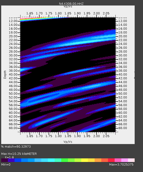
| Estimated Moho Depth: |
10.25 km |
| Estimated Crust Vp/Vs: |
1.60 |
| Assumed Crust Vp: |
6.53 km/s |
| Estimated Crust Vs: |
4.082 km/s |
| Estimated Crust Poisson's Ratio: |
0.18 |
|
| Radial Match: |
90.32973 % |
| Radial Bump: |
353 |
| Transverse Match: |
72.47596 % |
| Transverse Bump: |
400 |
| SOD ConfigId: |
18369291 |
| Insert Time: |
2019-06-10 09:55:53.771 +0000 |
| GWidth: |
2.5 |
| Max Bumps: |
400 |
| Tol: |
0.001 |
|

Signal To Noise
| Channel | StoN | STA | LTA |
| N4:K30B:00:HHZ:20190527T09:58:45.959006Z | 2.7925348 | 2.67528E-7 | 9.5801134E-8 |
| N4:K30B:00:HH1:20190527T09:58:45.959006Z | 1.9094906 | 2.9462362E-7 | 1.5429437E-7 |
| N4:K30B:00:HH2:20190527T09:58:45.959006Z | 0.8770384 | 1.2578074E-7 | 1.434153E-7 |
| Arrivals |
| Ps | 1.0 SECOND |
| PpPs | 3.7 SECOND |
| PsPs/PpSs | 4.8 SECOND |


