GPO China Lake , California, USA - Earthquake Result Viewer
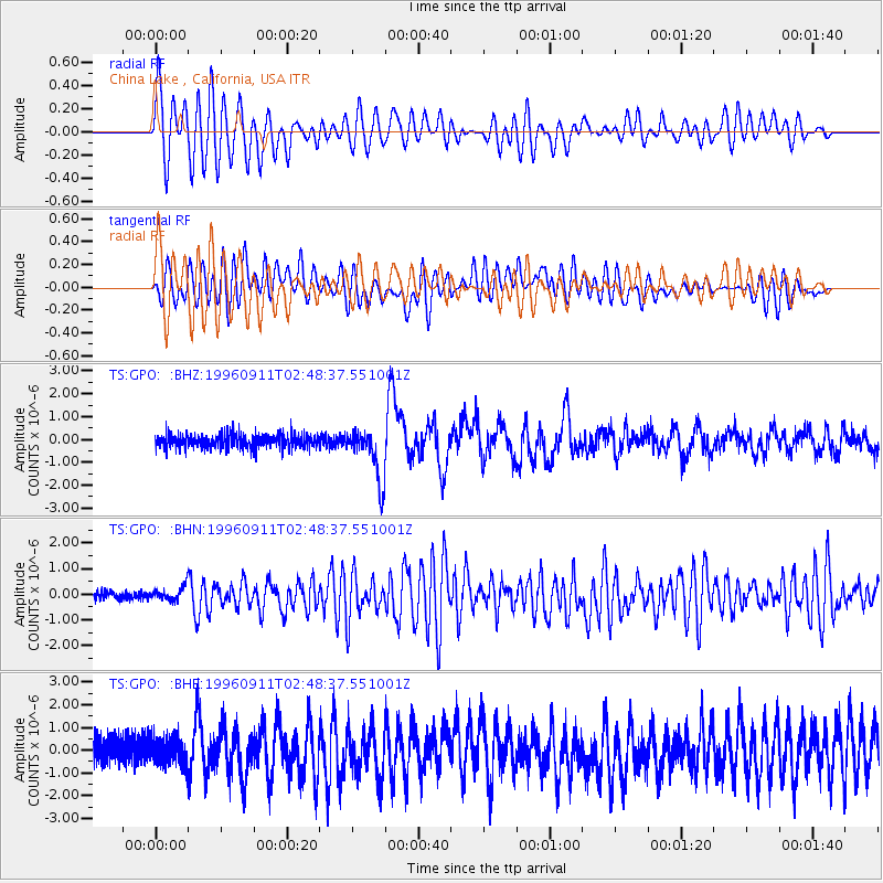
Earthquake location: Near East Coast Of Honshu, Japan
Earthquake latitude/longitude: 35.5/140.9
Earthquake time(UTC): 1996/09/11 (255) 02:37:14 GMT
Earthquake Depth: 55 km
Earthquake Magnitude: 6.1 MB, 5.7 MS, 6.2 UNKNOWN, 6.1 MW
Earthquake Catalog/Contributor: WHDF/NEIC
Network: TS TERRAscope (Southern California Seismic Network)
Station: GPO China Lake , California, USA
Lat/Lon: 35.65 N/117.66 W
Elevation: 735 m
Distance: 78.2 deg
Az: 54.65 deg
Baz: 305.237 deg
Ray Param: 0.04969989
Estimated Moho Depth: 19.0 km
Estimated Crust Vp/Vs: 1.92
Assumed Crust Vp: 6.276 km/s
Estimated Crust Vs: 3.26 km/s
Estimated Crust Poisson's Ratio: 0.32
Radial Match: 86.78068 %
Radial Bump: 400
Transverse Match: 80.334595 %
Transverse Bump: 400
SOD ConfigId: 6273
Insert Time: 2010-02-26 14:14:23.939 +0000
GWidth: 2.5
Max Bumps: 400
Tol: 0.001

Signal To Noise

ChannelStoNSTALTA
TS:GPO: :BHN:19960911T02:48:37.551001Z1.90313662.5120568E-71.3199562E-7
TS:GPO: :BHE:19960911T02:48:37.551001Z1.10032496.182209E-75.618531E-7
TS:GPO: :BHZ:19960911T02:48:37.551001Z3.90208131.1354552E-62.909871E-7
Arrivals
Ps2.9 SECOND
PpPs8.6 SECOND
PsPs/PpSs12 SECOND