You are here: Home > Network List > N4 - Central and EAstern US Network Stations List
> Station Q51A Peebles, OH, USA > Earthquake Result Viewer
Q51A Peebles, OH, USA - Earthquake Result Viewer
| Earthquake location: |
Kodiak Island Region, Alaska |
| Earthquake latitude/longitude: |
58.9/-152.4 |
| Earthquake time(UTC): |
2019/05/27 (147) 09:52:21 GMT |
| Earthquake Depth: |
65 km |
| Earthquake Magnitude: |
5.7 ML |
| Earthquake Catalog/Contributor: |
NEIC PDE/ak |
|
| Network: |
N4 Central and EAstern US Network |
| Station: |
Q51A Peebles, OH, USA |
| Lat/Lon: |
39.03 N/83.35 W |
| Elevation: |
362 m |
|
| Distance: |
47.1 deg |
| Az: |
83.142 deg |
| Baz: |
318.518 deg |
| Ray Param: |
0.07002009 |
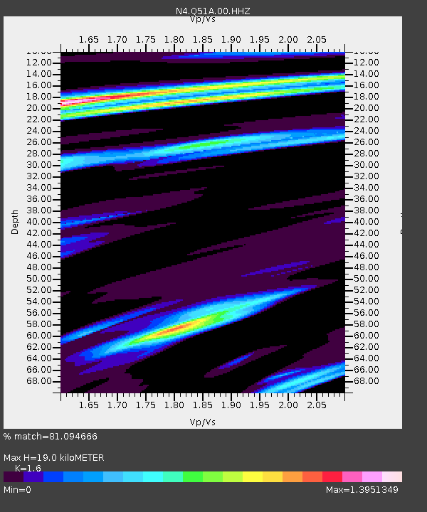
| Estimated Moho Depth: |
19.0 km |
| Estimated Crust Vp/Vs: |
1.60 |
| Assumed Crust Vp: |
6.232 km/s |
| Estimated Crust Vs: |
3.895 km/s |
| Estimated Crust Poisson's Ratio: |
0.18 |
|
| Radial Match: |
81.094666 % |
| Radial Bump: |
400 |
| Transverse Match: |
62.133068 % |
| Transverse Bump: |
400 |
| SOD ConfigId: |
18369291 |
| Insert Time: |
2019-06-10 09:56:03.774 +0000 |
| GWidth: |
2.5 |
| Max Bumps: |
400 |
| Tol: |
0.001 |
|

Signal To Noise
| Channel | StoN | STA | LTA |
| N4:Q51A:00:HHZ:20190527T10:00:16.489004Z | 2.418867 | 2.1633538E-7 | 8.9436654E-8 |
| N4:Q51A:00:HH1:20190527T10:00:16.489004Z | 1.2284801 | 1.3513714E-7 | 1.10003526E-7 |
| N4:Q51A:00:HH2:20190527T10:00:16.489004Z | 0.83229166 | 9.4485195E-8 | 1.13524145E-7 |
| Arrivals |
| Ps | 2.0 SECOND |
| PpPs | 7.4 SECOND |
| PsPs/PpSs | 9.4 SECOND |


