You are here: Home > Network List > TA - USArray Transportable Network (new EarthScope stations) Stations List
> Station W20A Ramah, NM, USA > Earthquake Result Viewer
W20A Ramah, NM, USA - Earthquake Result Viewer
| Earthquake location: |
Southern Peru |
| Earthquake latitude/longitude: |
-16.0/-71.7 |
| Earthquake time(UTC): |
2008/07/08 (190) 09:13:07 GMT |
| Earthquake Depth: |
123 km |
| Earthquake Magnitude: |
5.8 MB, 6.2 MW, 6.2 MW |
| Earthquake Catalog/Contributor: |
WHDF/NEIC |
|
| Network: |
TA USArray Transportable Network (new EarthScope stations) |
| Station: |
W20A Ramah, NM, USA |
| Lat/Lon: |
35.13 N/108.50 W |
| Elevation: |
2110 m |
|
| Distance: |
61.6 deg |
| Az: |
326.128 deg |
| Baz: |
139.159 deg |
| Ray Param: |
0.060390122 |
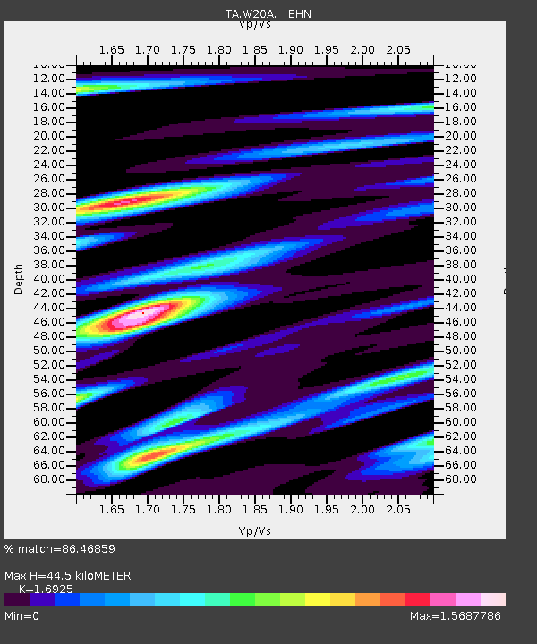
| Estimated Moho Depth: |
44.5 km |
| Estimated Crust Vp/Vs: |
1.69 |
| Assumed Crust Vp: |
6.496 km/s |
| Estimated Crust Vs: |
3.838 km/s |
| Estimated Crust Poisson's Ratio: |
0.23 |
|
| Radial Match: |
86.46859 % |
| Radial Bump: |
400 |
| Transverse Match: |
69.977394 % |
| Transverse Bump: |
400 |
| SOD ConfigId: |
2504 |
| Insert Time: |
2010-03-06 23:02:55.488 +0000 |
| GWidth: |
2.5 |
| Max Bumps: |
400 |
| Tol: |
0.001 |
|
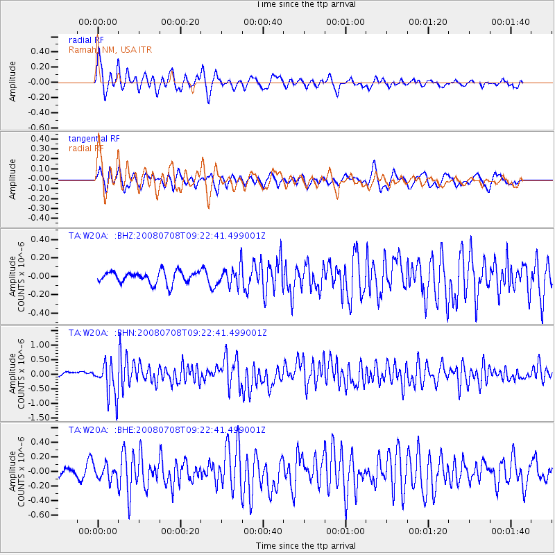
Signal To Noise
| Channel | StoN | STA | LTA |
| TA:W20A: :BHN:20080708T09:22:41.499001Z | 6.3693247 | 5.97669E-7 | 9.383553E-8 |
| TA:W20A: :BHE:20080708T09:22:41.499001Z | 1.5489955 | 9.639419E-8 | 6.223013E-8 |
| TA:W20A: :BHZ:20080708T09:22:41.499001Z | 1.6754988 | 1.0835121E-7 | 6.466803E-8 |
| Arrivals |
| Ps | 5.0 SECOND |
| PpPs | 18 SECOND |
| PsPs/PpSs | 23 SECOND |


