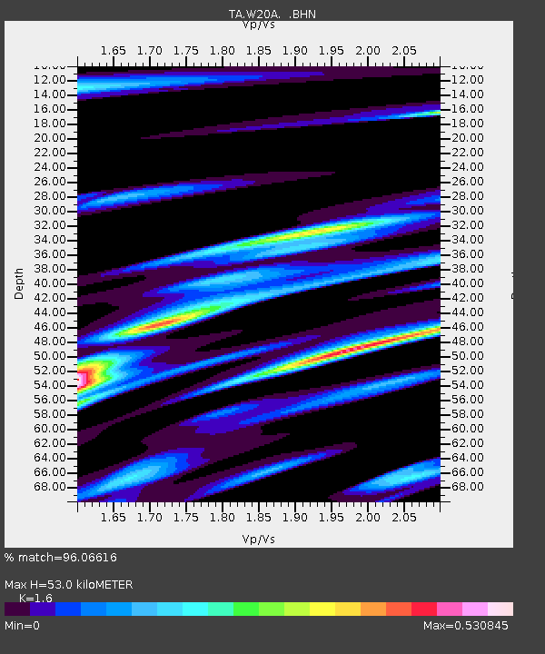
W20A Ramah, NM, USA - Earthquake Result Viewer
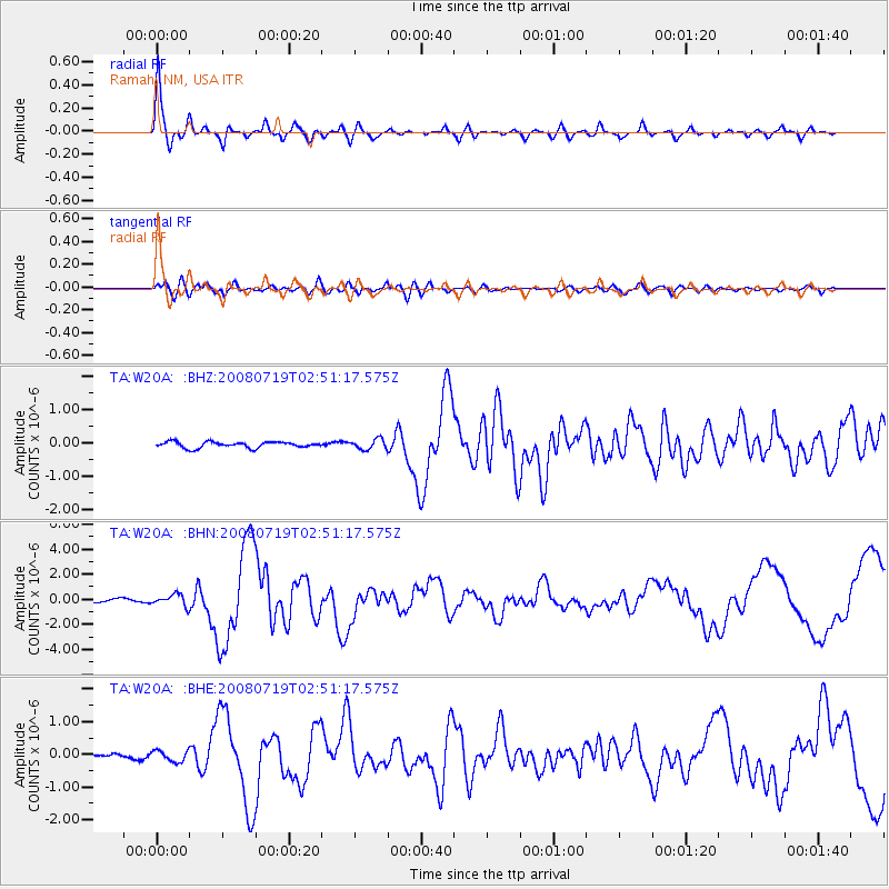
Earthquake location: Off East Coast Of Honshu, Japan
Earthquake latitude/longitude: 37.6/142.2
Earthquake time(UTC): 2008/07/19 (201) 02:39:28 GMT
Earthquake Depth: 22 km
Earthquake Magnitude: 6.2 MB, 7.0 MS, 7.0 MW, 6.9 MW
Earthquake Catalog/Contributor: WHDF/NEIC
Network: TA USArray Transportable Network (new EarthScope stations)
Station: W20A Ramah, NM, USA
Lat/Lon: 35.13 N/108.50 W
Elevation: 2110 m
Distance: 82.4 deg
Az: 51.314 deg
Baz: 310.814 deg
Ray Param: 0.0469
Estimated Moho Depth: 53.0 km
Estimated Crust Vp/Vs: 1.60
Assumed Crust Vp: 6.496 km/s
Estimated Crust Vs: 4.06 km/s
Estimated Crust Poisson's Ratio: 0.18
Radial Match: 96.06616 %
Radial Bump: 400
Transverse Match: 85.49776 %
Transverse Bump: 400
SOD ConfigId: 2504
Insert Time: 2010-03-06 23:02:57.842 +0000
GWidth: 2.5
Max Bumps: 400
Tol: 0.001

Signal To Noise

ChannelStoNSTALTA
TA:W20A: :BHN:20080719T02:51:17.575Z3.3491734.6130322E-71.3773645E-7
TA:W20A: :BHE:20080719T02:51:17.575Z2.25007461.7026423E-77.567048E-8
TA:W20A: :BHZ:20080719T02:51:17.575Z1.72501441.543527E-78.947908E-8
Arrivals
Ps5.0 SECOND
PpPs21 SECOND
PsPs/PpSs26 SECOND