You are here: Home > Network List > TS - TERRAscope (Southern California Seismic Network) Stations List
> Station GPO China Lake , California, USA > Earthquake Result Viewer
GPO China Lake , California, USA - Earthquake Result Viewer
| Earthquake location: |
Santa Cruz Islands |
| Earthquake latitude/longitude: |
-12.6/166.7 |
| Earthquake time(UTC): |
1997/04/21 (111) 12:02:26 GMT |
| Earthquake Depth: |
33 km |
| Earthquake Magnitude: |
6.4 MB, 7.9 MS, 7.9 UNKNOWN, 7.8 MW |
| Earthquake Catalog/Contributor: |
WHDF/NEIC |
|
| Network: |
TS TERRAscope (Southern California Seismic Network) |
| Station: |
GPO China Lake , California, USA |
| Lat/Lon: |
35.65 N/117.66 W |
| Elevation: |
735 m |
|
| Distance: |
85.9 deg |
| Az: |
52.288 deg |
| Baz: |
251.494 deg |
| Ray Param: |
0.044383224 |
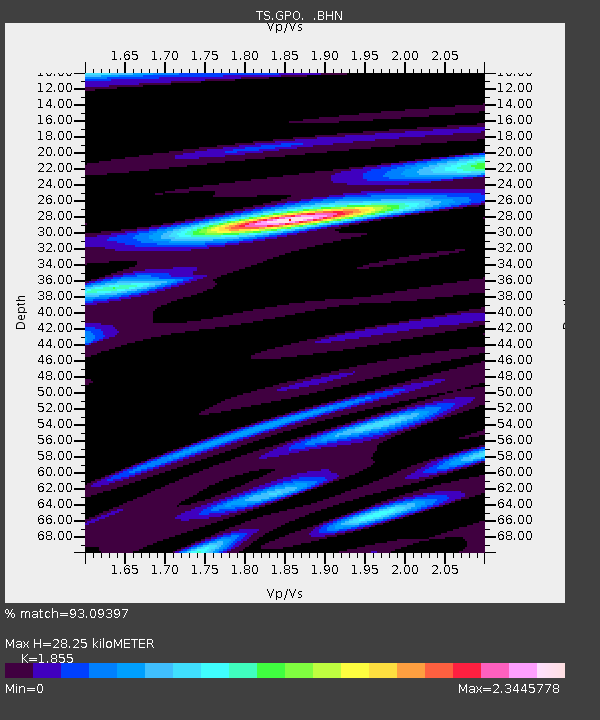
| Estimated Moho Depth: |
28.25 km |
| Estimated Crust Vp/Vs: |
1.86 |
| Assumed Crust Vp: |
6.276 km/s |
| Estimated Crust Vs: |
3.383 km/s |
| Estimated Crust Poisson's Ratio: |
0.30 |
|
| Radial Match: |
93.09397 % |
| Radial Bump: |
400 |
| Transverse Match: |
81.08443 % |
| Transverse Bump: |
400 |
| SOD ConfigId: |
6273 |
| Insert Time: |
2010-02-26 14:14:25.466 +0000 |
| GWidth: |
2.5 |
| Max Bumps: |
400 |
| Tol: |
0.001 |
|
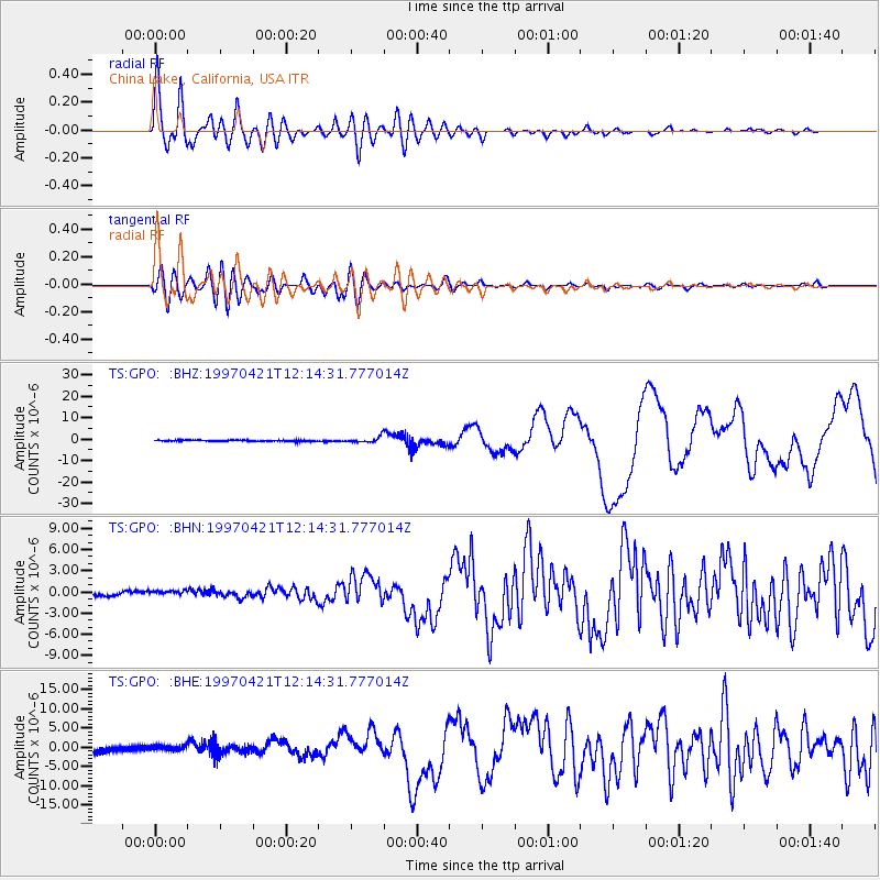
Signal To Noise
| Channel | StoN | STA | LTA |
| TS:GPO: :BHN:19970421T12:14:31.777014Z | 3.083753 | 6.473611E-7 | 2.0992638E-7 |
| TS:GPO: :BHE:19970421T12:14:31.777014Z | 2.2309425 | 1.1928989E-6 | 5.3470626E-7 |
| TS:GPO: :BHZ:19970421T12:14:31.777014Z | 4.575673 | 1.321754E-6 | 2.888655E-7 |
| Arrivals |
| Ps | 3.9 SECOND |
| PpPs | 13 SECOND |
| PsPs/PpSs | 17 SECOND |


