You are here: Home > Network List > TA - USArray Transportable Network (new EarthScope stations) Stations List
> Station W20A Ramah, NM, USA > Earthquake Result Viewer
W20A Ramah, NM, USA - Earthquake Result Viewer
| Earthquake location: |
Tonga Islands |
| Earthquake latitude/longitude: |
-15.1/-173.5 |
| Earthquake time(UTC): |
2008/08/19 (232) 16:30:13 GMT |
| Earthquake Depth: |
8.0 km |
| Earthquake Magnitude: |
5.6 MB, 5.9 MS, 6.1 MW, 6.0 MW |
| Earthquake Catalog/Contributor: |
WHDF/NEIC |
|
| Network: |
TA USArray Transportable Network (new EarthScope stations) |
| Station: |
W20A Ramah, NM, USA |
| Lat/Lon: |
35.13 N/108.50 W |
| Elevation: |
2110 m |
|
| Distance: |
79.2 deg |
| Az: |
49.118 deg |
| Baz: |
242.996 deg |
| Ray Param: |
0.049103443 |
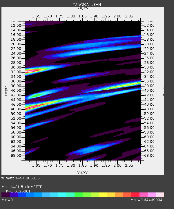
| Estimated Moho Depth: |
31.5 km |
| Estimated Crust Vp/Vs: |
1.61 |
| Assumed Crust Vp: |
6.496 km/s |
| Estimated Crust Vs: |
4.029 km/s |
| Estimated Crust Poisson's Ratio: |
0.19 |
|
| Radial Match: |
94.085815 % |
| Radial Bump: |
400 |
| Transverse Match: |
79.58514 % |
| Transverse Bump: |
391 |
| SOD ConfigId: |
2504 |
| Insert Time: |
2010-03-06 23:03:07.584 +0000 |
| GWidth: |
2.5 |
| Max Bumps: |
400 |
| Tol: |
0.001 |
|
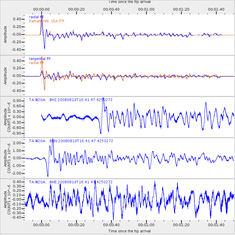
Signal To Noise
| Channel | StoN | STA | LTA |
| TA:W20A: :BHN:20080819T16:41:47.425027Z | 14.695874 | 9.3636226E-7 | 6.3715994E-8 |
| TA:W20A: :BHE:20080819T16:41:47.425027Z | 1.1668913 | 9.705249E-8 | 8.3171834E-8 |
| TA:W20A: :BHZ:20080819T16:41:47.425027Z | 4.1156373 | 3.4615815E-7 | 8.410803E-8 |
| Arrivals |
| Ps | 3.1 SECOND |
| PpPs | 12 SECOND |
| PsPs/PpSs | 15 SECOND |


