You are here: Home > Network List > TX - Texas Seismological Network Stations List
> Station PB05 Z > Earthquake Result Viewer
PB05 Z - Earthquake Result Viewer
| Earthquake location: |
Kodiak Island Region, Alaska |
| Earthquake latitude/longitude: |
58.9/-152.4 |
| Earthquake time(UTC): |
2019/05/27 (147) 09:52:21 GMT |
| Earthquake Depth: |
65 km |
| Earthquake Magnitude: |
5.7 ML |
| Earthquake Catalog/Contributor: |
NEIC PDE/ak |
|
| Network: |
TX Texas Seismological Network |
| Station: |
PB05 Z |
| Lat/Lon: |
30.92 N/103.32 W |
| Elevation: |
957 m |
|
| Distance: |
43.1 deg |
| Az: |
108.392 deg |
| Baz: |
324.985 deg |
| Ray Param: |
0.07254125 |
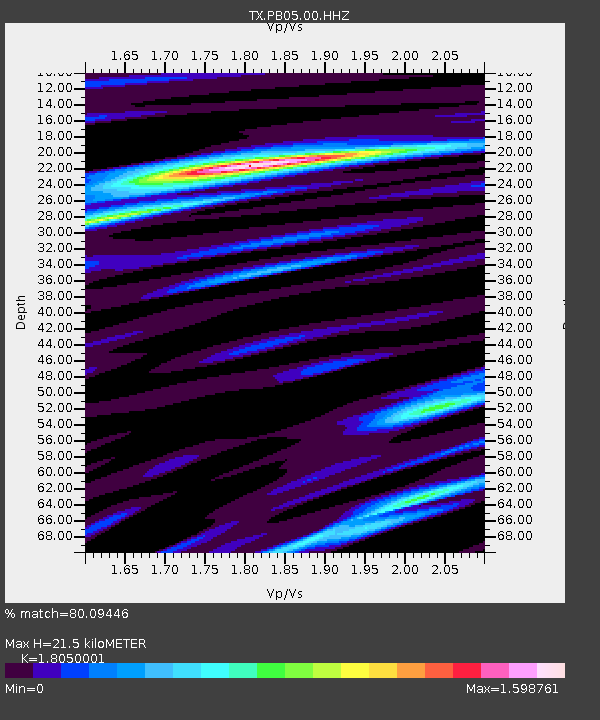
| Estimated Moho Depth: |
21.5 km |
| Estimated Crust Vp/Vs: |
1.81 |
| Assumed Crust Vp: |
6.121 km/s |
| Estimated Crust Vs: |
3.391 km/s |
| Estimated Crust Poisson's Ratio: |
0.28 |
|
| Radial Match: |
80.09446 % |
| Radial Bump: |
400 |
| Transverse Match: |
77.176674 % |
| Transverse Bump: |
400 |
| SOD ConfigId: |
18369291 |
| Insert Time: |
2019-06-10 09:58:04.333 +0000 |
| GWidth: |
2.5 |
| Max Bumps: |
400 |
| Tol: |
0.001 |
|

Signal To Noise
| Channel | StoN | STA | LTA |
| TX:PB05:00:HHZ:20190527T09:59:45.219992Z | 1.7079659 | 3.0548702E-7 | 1.7886015E-7 |
| TX:PB05:00:HH1:20190527T09:59:45.219992Z | 1.1793299 | 1.5796265E-7 | 1.3394272E-7 |
| TX:PB05:00:HH2:20190527T09:59:45.219992Z | 0.85163426 | 9.115579E-8 | 1.07036314E-7 |
| Arrivals |
| Ps | 3.0 SECOND |
| PpPs | 9.3 SECOND |
| PsPs/PpSs | 12 SECOND |


