You are here: Home > Network List > UU - University of Utah Regional Network Stations List
> Station CVRU Castle Valley Ranch, Emery, UT, USA old TA-Q16A > Earthquake Result Viewer
CVRU Castle Valley Ranch, Emery, UT, USA old TA-Q16A - Earthquake Result Viewer
| Earthquake location: |
Kodiak Island Region, Alaska |
| Earthquake latitude/longitude: |
58.9/-152.4 |
| Earthquake time(UTC): |
2019/05/27 (147) 09:52:21 GMT |
| Earthquake Depth: |
65 km |
| Earthquake Magnitude: |
5.7 ML |
| Earthquake Catalog/Contributor: |
NEIC PDE/ak |
|
| Network: |
UU University of Utah Regional Network |
| Station: |
CVRU Castle Valley Ranch, Emery, UT, USA old TA-Q16A |
| Lat/Lon: |
38.92 N/111.17 W |
| Elevation: |
1912 m |
|
| Distance: |
32.9 deg |
| Az: |
108.965 deg |
| Baz: |
320.951 deg |
| Ray Param: |
0.07829432 |
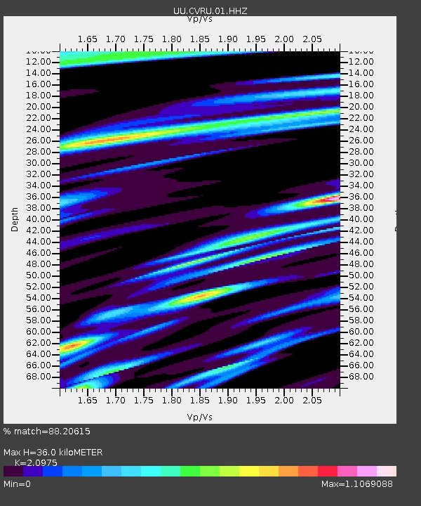
| Estimated Moho Depth: |
36.0 km |
| Estimated Crust Vp/Vs: |
2.10 |
| Assumed Crust Vp: |
6.207 km/s |
| Estimated Crust Vs: |
2.959 km/s |
| Estimated Crust Poisson's Ratio: |
0.35 |
|
| Radial Match: |
88.20615 % |
| Radial Bump: |
346 |
| Transverse Match: |
85.48098 % |
| Transverse Bump: |
400 |
| SOD ConfigId: |
18369291 |
| Insert Time: |
2019-06-10 09:58:20.657 +0000 |
| GWidth: |
2.5 |
| Max Bumps: |
400 |
| Tol: |
0.001 |
|
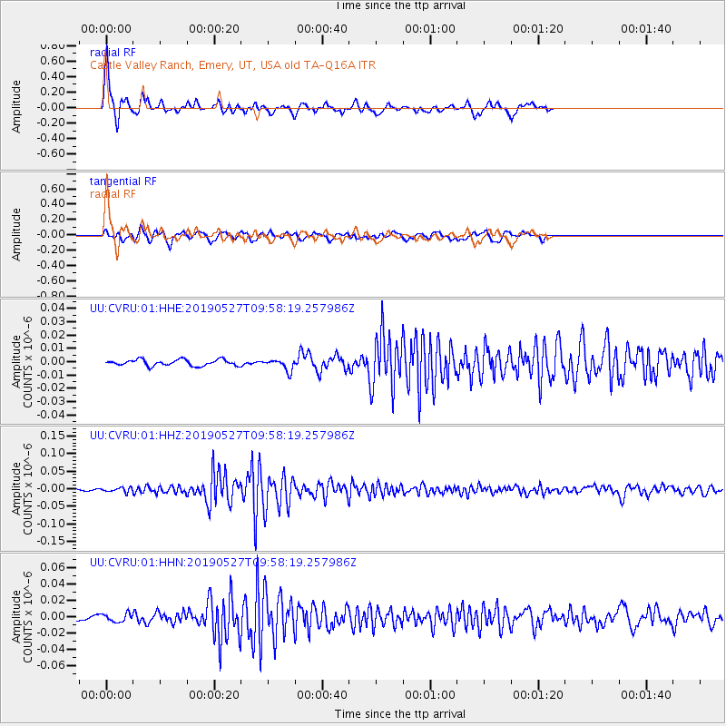
Signal To Noise
| Channel | StoN | STA | LTA |
| UU:CVRU:01:HHZ:20190527T09:58:19.257986Z | 2.5107465 | 6.4275967E-9 | 2.560034E-9 |
| UU:CVRU:01:HHN:20190527T09:58:19.257986Z | 2.2026784 | 4.985128E-9 | 2.2632116E-9 |
| UU:CVRU:01:HHE:20190527T09:58:19.257986Z | 1.9653832 | 4.4642188E-9 | 2.271424E-9 |
| Arrivals |
| Ps | 6.8 SECOND |
| PpPs | 17 SECOND |
| PsPs/PpSs | 24 SECOND |


