You are here: Home > Network List > TA - USArray Transportable Network (new EarthScope stations) Stations List
> Station W20A Ramah, NM, USA > Earthquake Result Viewer
W20A Ramah, NM, USA - Earthquake Result Viewer
| Earthquake location: |
Tonga Islands |
| Earthquake latitude/longitude: |
-15.4/-173.3 |
| Earthquake time(UTC): |
2009/10/01 (274) 06:13:32 GMT |
| Earthquake Depth: |
10 km |
| Earthquake Magnitude: |
5.6 MB, 5.7 MS, 5.8 MW, 5.7 MW |
| Earthquake Catalog/Contributor: |
WHDF/NEIC |
|
| Network: |
TA USArray Transportable Network (new EarthScope stations) |
| Station: |
W20A Ramah, NM, USA |
| Lat/Lon: |
35.13 N/108.50 W |
| Elevation: |
2110 m |
|
| Distance: |
79.3 deg |
| Az: |
48.99 deg |
| Baz: |
242.622 deg |
| Ray Param: |
0.049078673 |
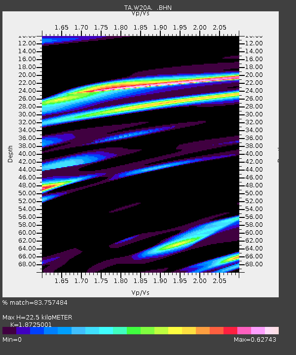
| Estimated Moho Depth: |
22.5 km |
| Estimated Crust Vp/Vs: |
1.87 |
| Assumed Crust Vp: |
6.496 km/s |
| Estimated Crust Vs: |
3.469 km/s |
| Estimated Crust Poisson's Ratio: |
0.30 |
|
| Radial Match: |
83.757484 % |
| Radial Bump: |
395 |
| Transverse Match: |
79.82994 % |
| Transverse Bump: |
400 |
| SOD ConfigId: |
2622 |
| Insert Time: |
2010-03-06 23:03:57.138 +0000 |
| GWidth: |
2.5 |
| Max Bumps: |
400 |
| Tol: |
0.001 |
|

Signal To Noise
| Channel | StoN | STA | LTA |
| TA:W20A: :BHN:20091001T06:25:06.699011Z | 3.3264465 | 3.3080002E-7 | 9.9445465E-8 |
| TA:W20A: :BHE:20091001T06:25:06.699011Z | 1.3019085 | 1.2067449E-7 | 9.269045E-8 |
| TA:W20A: :BHZ:20091001T06:25:06.699011Z | 2.321816 | 2.1524713E-7 | 9.2706365E-8 |
| Arrivals |
| Ps | 3.1 SECOND |
| PpPs | 9.7 SECOND |
| PsPs/PpSs | 13 SECOND |


