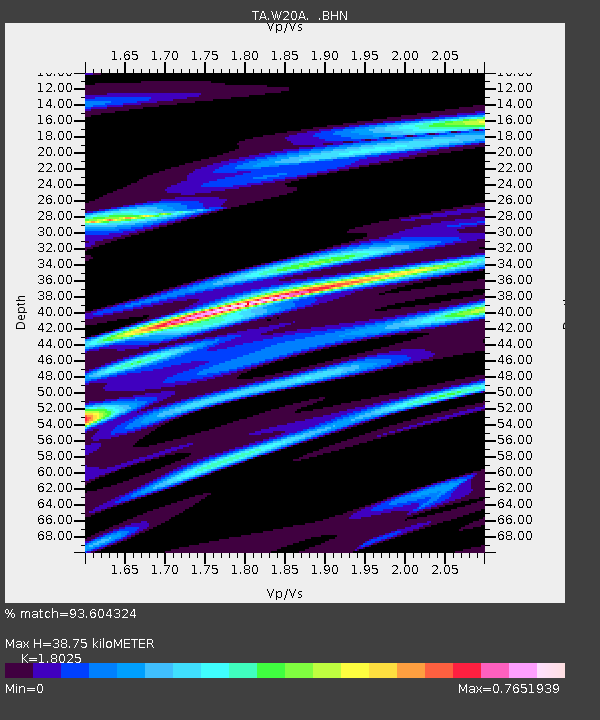
W20A Ramah, NM, USA - Earthquake Result Viewer

Earthquake location: Fox Islands, Aleutian Islands
Earthquake latitude/longitude: 52.8/-167.0
Earthquake time(UTC): 2009/10/13 (286) 05:37:23 GMT
Earthquake Depth: 24 km
Earthquake Magnitude: 6.0 MB, 6.1 MS, 6.5 MW, 6.5 MW
Earthquake Catalog/Contributor: WHDF/NEIC
Network: TA USArray Transportable Network (new EarthScope stations)
Station: W20A Ramah, NM, USA
Lat/Lon: 35.13 N/108.50 W
Elevation: 2110 m
Distance: 44.3 deg
Az: 89.343 deg
Baz: 312.144 deg
Ray Param: 0.071938574
Estimated Moho Depth: 38.75 km
Estimated Crust Vp/Vs: 1.80
Assumed Crust Vp: 6.496 km/s
Estimated Crust Vs: 3.604 km/s
Estimated Crust Poisson's Ratio: 0.28
Radial Match: 93.604324 %
Radial Bump: 344
Transverse Match: 71.13735 %
Transverse Bump: 400
SOD ConfigId: 2622
Insert Time: 2010-03-06 23:04:02.154 +0000
GWidth: 2.5
Max Bumps: 400
Tol: 0.001

Signal To Noise

ChannelStoNSTALTA
TA:W20A: :BHN:20091013T05:45:01.07501Z1.55691594.2894223E-72.7550763E-7
TA:W20A: :BHE:20091013T05:45:01.07501Z1.25542821.4374837E-71.1450146E-7
TA:W20A: :BHZ:20091013T05:45:01.07501Z1.40203053.383384E-72.413203E-7
Arrivals
Ps5.1 SECOND
PpPs16 SECOND
PsPs/PpSs21 SECOND