You are here: Home > Network List > TA - USArray Transportable Network (new EarthScope stations) Stations List
> Station W20A Ramah, NM, USA > Earthquake Result Viewer
W20A Ramah, NM, USA - Earthquake Result Viewer

| Earthquake location: |
Ryukyu Islands, Japan |
| Earthquake latitude/longitude: |
29.2/129.8 |
| Earthquake time(UTC): |
2009/10/30 (303) 07:03:39 GMT |
| Earthquake Depth: |
34 km |
| Earthquake Magnitude: |
6.3 MB, 6.8 MS, 6.8 MW, 6.8 MW |
| Earthquake Catalog/Contributor: |
WHDF/NEIC |
|
| Network: |
TA USArray Transportable Network (new EarthScope stations) |
| Station: |
W20A Ramah, NM, USA |
| Lat/Lon: |
35.13 N/108.50 W |
| Elevation: |
2110 m |
|
| Distance: |
95.7 deg |
| Az: |
44.482 deg |
| Baz: |
311.648 deg |
| Ray Param: |
0.040709466 |
| Estimated Moho Depth: |
54.0 km |
| Estimated Crust Vp/Vs: |
1.60 |
| Assumed Crust Vp: |
6.496 km/s |
| Estimated Crust Vs: |
4.06 km/s |
| Estimated Crust Poisson's Ratio: |
0.18 |
|
| Radial Match: |
81.601585 % |
| Radial Bump: |
400 |
| Transverse Match: |
62.066948 % |
| Transverse Bump: |
400 |
| SOD ConfigId: |
2622 |
| Insert Time: |
2010-03-06 23:04:05.882 +0000 |
| GWidth: |
2.5 |
| Max Bumps: |
400 |
| Tol: |
0.001 |
|
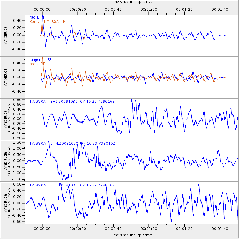
Signal To Noise
| Channel | StoN | STA | LTA |
| TA:W20A: :BHN:20091030T07:16:29.799016Z | 6.476511 | 7.646825E-7 | 1.1807013E-7 |
| TA:W20A: :BHE:20091030T07:16:29.799016Z | 2.1654909 | 2.4645163E-7 | 1.1380867E-7 |
| TA:W20A: :BHZ:20091030T07:16:29.799016Z | 1.8288511 | 3.097214E-7 | 1.6935299E-7 |
| Arrivals |
| Ps | 5.1 SECOND |
| PpPs | 21 SECOND |
| PsPs/PpSs | 26 SECOND |


