You are here: Home > Network List > TA - USArray Transportable Network (new EarthScope stations) Stations List
> Station W20A Ramah, NM, USA > Earthquake Result Viewer
W20A Ramah, NM, USA - Earthquake Result Viewer
| Earthquake location: |
Tonga Islands |
| Earthquake latitude/longitude: |
-15.5/-173.8 |
| Earthquake time(UTC): |
2009/11/01 (305) 21:28:58 GMT |
| Earthquake Depth: |
105 km |
| Earthquake Magnitude: |
5.8 MW, 5.4 MB, 5.8 MW |
| Earthquake Catalog/Contributor: |
WHDF/NEIC |
|
| Network: |
TA USArray Transportable Network (new EarthScope stations) |
| Station: |
W20A Ramah, NM, USA |
| Lat/Lon: |
35.13 N/108.50 W |
| Elevation: |
2110 m |
|
| Distance: |
79.7 deg |
| Az: |
49.165 deg |
| Baz: |
242.854 deg |
| Ray Param: |
0.048538536 |
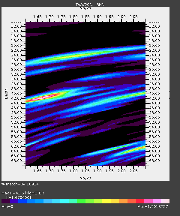
| Estimated Moho Depth: |
41.5 km |
| Estimated Crust Vp/Vs: |
1.67 |
| Assumed Crust Vp: |
6.496 km/s |
| Estimated Crust Vs: |
3.89 km/s |
| Estimated Crust Poisson's Ratio: |
0.22 |
|
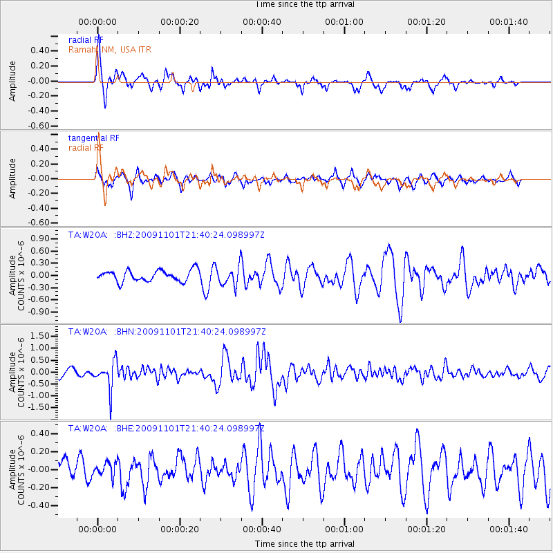
| Radial Match: |
84.18924 % |
| Radial Bump: |
347 |
| Transverse Match: |
57.986347 % |
| Transverse Bump: |
369 |
| SOD ConfigId: |
2622 |
| Insert Time: |
2010-03-06 23:04:08.828 +0000 |
| GWidth: |
2.5 |
| Max Bumps: |
400 |
| Tol: |
0.001 |
|
Signal To Noise
| Channel | StoN | STA | LTA |
| TA:W20A: :BHN:20091101T21:40:24.098997Z | 4.642649 | 5.925775E-7 | 1.276378E-7 |
| TA:W20A: :BHE:20091101T21:40:24.098997Z | 0.38021633 | 7.8148446E-8 | 2.0553681E-7 |
| TA:W20A: :BHZ:20091101T21:40:24.098997Z | 1.7882272 | 2.4189805E-7 | 1.3527254E-7 |
| Arrivals |
| Ps | 4.4 SECOND |
| PpPs | 17 SECOND |
| PsPs/PpSs | 21 SECOND |


