You are here: Home > Network List > TA - USArray Transportable Network (new EarthScope stations) Stations List
> Station W20A Ramah, NM, USA > Earthquake Result Viewer
W20A Ramah, NM, USA - Earthquake Result Viewer
| Earthquake location: |
Sea Of Okhotsk |
| Earthquake latitude/longitude: |
54.2/154.3 |
| Earthquake time(UTC): |
2008/11/24 (329) 09:02:58 GMT |
| Earthquake Depth: |
492 km |
| Earthquake Magnitude: |
6.5 MB, 7.3 MW, 7.3 MW |
| Earthquake Catalog/Contributor: |
WHDF/NEIC |
|
| Network: |
TA USArray Transportable Network (new EarthScope stations) |
| Station: |
W20A Ramah, NM, USA |
| Lat/Lon: |
35.13 N/108.50 W |
| Elevation: |
2110 m |
|
| Distance: |
66.2 deg |
| Az: |
62.72 deg |
| Baz: |
320.431 deg |
| Ray Param: |
0.05605459 |
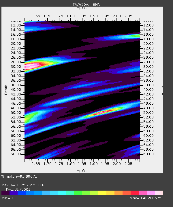
| Estimated Moho Depth: |
30.25 km |
| Estimated Crust Vp/Vs: |
1.62 |
| Assumed Crust Vp: |
6.496 km/s |
| Estimated Crust Vs: |
4.016 km/s |
| Estimated Crust Poisson's Ratio: |
0.19 |
|
| Radial Match: |
91.69671 % |
| Radial Bump: |
271 |
| Transverse Match: |
73.39476 % |
| Transverse Bump: |
314 |
| SOD ConfigId: |
2658 |
| Insert Time: |
2010-03-06 23:04:14.199 +0000 |
| GWidth: |
2.5 |
| Max Bumps: |
400 |
| Tol: |
0.001 |
|

Signal To Noise
| Channel | StoN | STA | LTA |
| TA:W20A: :BHN:20081124T09:12:26.200002Z | 17.021065 | 3.5225153E-6 | 2.0695035E-7 |
| TA:W20A: :BHE:20081124T09:12:26.200002Z | 8.7191515 | 1.1873063E-6 | 1.3617223E-7 |
| TA:W20A: :BHZ:20081124T09:12:26.200002Z | 4.173391 | 9.03114E-7 | 2.1639816E-7 |
| Arrivals |
| Ps | 3.0 SECOND |
| PpPs | 12 SECOND |
| PsPs/PpSs | 15 SECOND |


