You are here: Home > Network List > AK - Alaska Regional Network Stations List
> Station PPLA Purkeypile > Earthquake Result Viewer
PPLA Purkeypile - Earthquake Result Viewer
| Earthquake location: |
El Salvador |
| Earthquake latitude/longitude: |
13.1/-89.4 |
| Earthquake time(UTC): |
2019/05/30 (150) 09:03:31 GMT |
| Earthquake Depth: |
10 km |
| Earthquake Magnitude: |
6.6 Mi |
| Earthquake Catalog/Contributor: |
NEIC PDE/at |
|
| Network: |
AK Alaska Regional Network |
| Station: |
PPLA Purkeypile |
| Lat/Lon: |
62.90 N/152.19 W |
| Elevation: |
1519 m |
|
| Distance: |
66.1 deg |
| Az: |
333.544 deg |
| Baz: |
108.629 deg |
| Ray Param: |
0.057806797 |
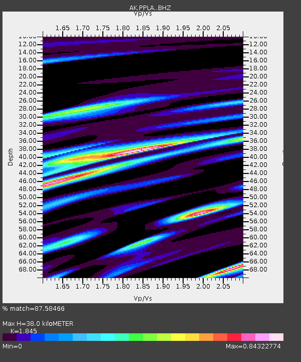
| Estimated Moho Depth: |
38.0 km |
| Estimated Crust Vp/Vs: |
1.85 |
| Assumed Crust Vp: |
6.566 km/s |
| Estimated Crust Vs: |
3.559 km/s |
| Estimated Crust Poisson's Ratio: |
0.29 |
|
| Radial Match: |
87.58466 % |
| Radial Bump: |
400 |
| Transverse Match: |
73.78338 % |
| Transverse Bump: |
400 |
| SOD ConfigId: |
18369291 |
| Insert Time: |
2019-06-13 09:04:17.065 +0000 |
| GWidth: |
2.5 |
| Max Bumps: |
400 |
| Tol: |
0.001 |
|

Signal To Noise
| Channel | StoN | STA | LTA |
| AK:PPLA: :BHZ:20190530T09:13:47.307983Z | 2.9878626 | 8.0396677E-7 | 2.6907756E-7 |
| AK:PPLA: :BHN:20190530T09:13:47.307983Z | 1.7296633 | 3.735288E-7 | 2.1595463E-7 |
| AK:PPLA: :BHE:20190530T09:13:47.307983Z | 4.7796507 | 6.157815E-7 | 1.28834E-7 |
| Arrivals |
| Ps | 5.1 SECOND |
| PpPs | 16 SECOND |
| PsPs/PpSs | 21 SECOND |


