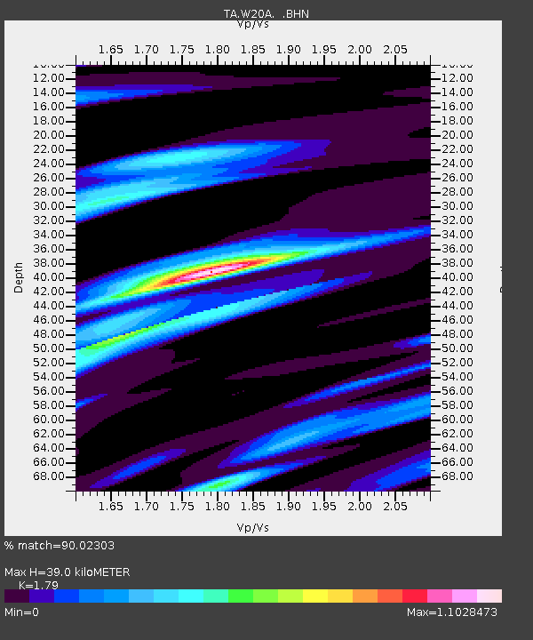
W20A Ramah, NM, USA - Earthquake Result Viewer
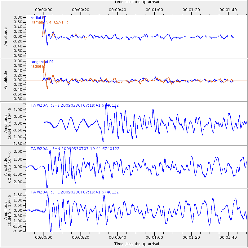
Earthquake location: Kodiak Island Region, Alaska
Earthquake latitude/longitude: 56.5/-152.7
Earthquake time(UTC): 2009/03/30 (089) 07:13:07 GMT
Earthquake Depth: 21 km
Earthquake Magnitude: 5.9 MB, 5.9 MS, 5.9 MW, 5.9 MW
Earthquake Catalog/Contributor: WHDF/NEIC
Network: TA USArray Transportable Network (new EarthScope stations)
Station: W20A Ramah, NM, USA
Lat/Lon: 35.13 N/108.50 W
Elevation: 2110 m
Distance: 36.7 deg
Az: 106.711 deg
Baz: 319.674 deg
Ray Param: 0.076530136
Estimated Moho Depth: 39.0 km
Estimated Crust Vp/Vs: 1.79
Assumed Crust Vp: 6.496 km/s
Estimated Crust Vs: 3.629 km/s
Estimated Crust Poisson's Ratio: 0.27
Radial Match: 90.02303 %
Radial Bump: 344
Transverse Match: 65.54144 %
Transverse Bump: 400
SOD ConfigId: 2658
Insert Time: 2010-03-06 23:04:32.227 +0000
GWidth: 2.5
Max Bumps: 400
Tol: 0.001

Signal To Noise

ChannelStoNSTALTA
TA:W20A: :BHN:20090330T07:19:41.674012Z7.21958731.4072688E-61.9492371E-7
TA:W20A: :BHE:20090330T07:19:41.674012Z8.209969.796291E-71.1932202E-7
TA:W20A: :BHZ:20090330T07:19:41.674012Z3.2786968.0961877E-72.4693315E-7
Arrivals
Ps5.1 SECOND
PpPs16 SECOND
PsPs/PpSs21 SECOND