You are here: Home > Network List > TA - USArray Transportable Network (new EarthScope stations) Stations List
> Station W20A Ramah, NM, USA > Earthquake Result Viewer
W20A Ramah, NM, USA - Earthquake Result Viewer

| Earthquake location: |
Kuril Islands |
| Earthquake latitude/longitude: |
46.0/151.4 |
| Earthquake time(UTC): |
2009/04/18 (108) 19:17:58 GMT |
| Earthquake Depth: |
35 km |
| Earthquake Magnitude: |
6.3 MB, 6.3 MS, 6.6 MW, 6.4 MW |
| Earthquake Catalog/Contributor: |
WHDF/NEIC |
|
| Network: |
TA USArray Transportable Network (new EarthScope stations) |
| Station: |
W20A Ramah, NM, USA |
| Lat/Lon: |
35.13 N/108.50 W |
| Elevation: |
2110 m |
|
| Distance: |
71.9 deg |
| Az: |
58.119 deg |
| Baz: |
313.787 deg |
| Ray Param: |
0.053973977 |
| Estimated Moho Depth: |
43.75 km |
| Estimated Crust Vp/Vs: |
1.76 |
| Assumed Crust Vp: |
6.496 km/s |
| Estimated Crust Vs: |
3.691 km/s |
| Estimated Crust Poisson's Ratio: |
0.26 |
|
| Radial Match: |
90.88255 % |
| Radial Bump: |
400 |
| Transverse Match: |
76.410164 % |
| Transverse Bump: |
400 |
| SOD ConfigId: |
2760 |
| Insert Time: |
2010-03-06 23:04:36.426 +0000 |
| GWidth: |
2.5 |
| Max Bumps: |
400 |
| Tol: |
0.001 |
|
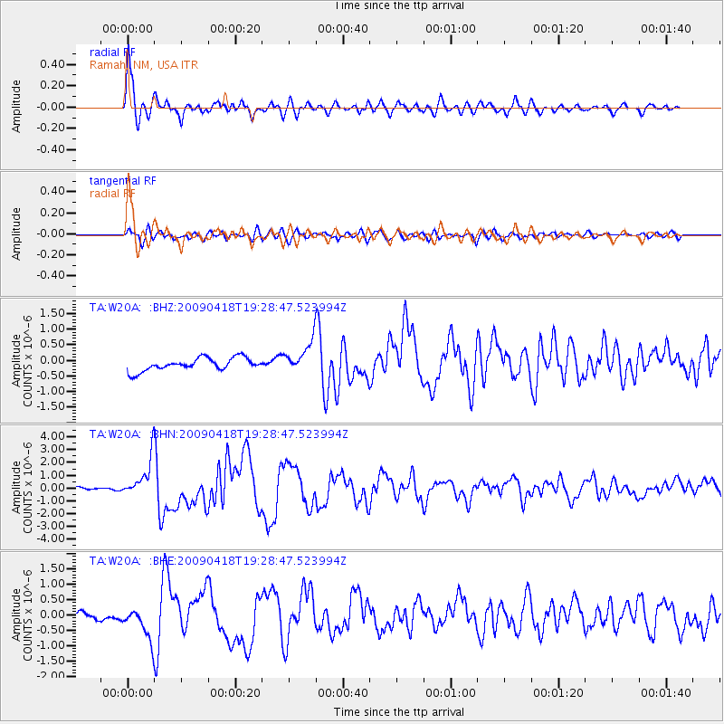
Signal To Noise
| Channel | StoN | STA | LTA |
| TA:W20A: :BHN:20090418T19:28:47.523994Z | 11.5749445 | 1.5109281E-6 | 1.3053437E-7 |
| TA:W20A: :BHE:20090418T19:28:47.523994Z | 4.7579436 | 5.646007E-7 | 1.18664865E-7 |
| TA:W20A: :BHZ:20090418T19:28:47.523994Z | 2.5268927 | 5.154245E-7 | 2.0397562E-7 |
| Arrivals |
| Ps | 5.3 SECOND |
| PpPs | 18 SECOND |
| PsPs/PpSs | 23 SECOND |


