You are here: Home > Network List > AZ - ANZA Regional Network Stations List
> Station LVA2 AZ.LVA2 > Earthquake Result Viewer
LVA2 AZ.LVA2 - Earthquake Result Viewer
| Earthquake location: |
El Salvador |
| Earthquake latitude/longitude: |
13.1/-89.4 |
| Earthquake time(UTC): |
2019/05/30 (150) 09:03:31 GMT |
| Earthquake Depth: |
10 km |
| Earthquake Magnitude: |
6.6 Mi |
| Earthquake Catalog/Contributor: |
NEIC PDE/at |
|
| Network: |
AZ ANZA Regional Network |
| Station: |
LVA2 AZ.LVA2 |
| Lat/Lon: |
33.35 N/116.56 W |
| Elevation: |
1435 m |
|
| Distance: |
31.9 deg |
| Az: |
313.659 deg |
| Baz: |
122.643 deg |
| Ray Param: |
0.07886931 |
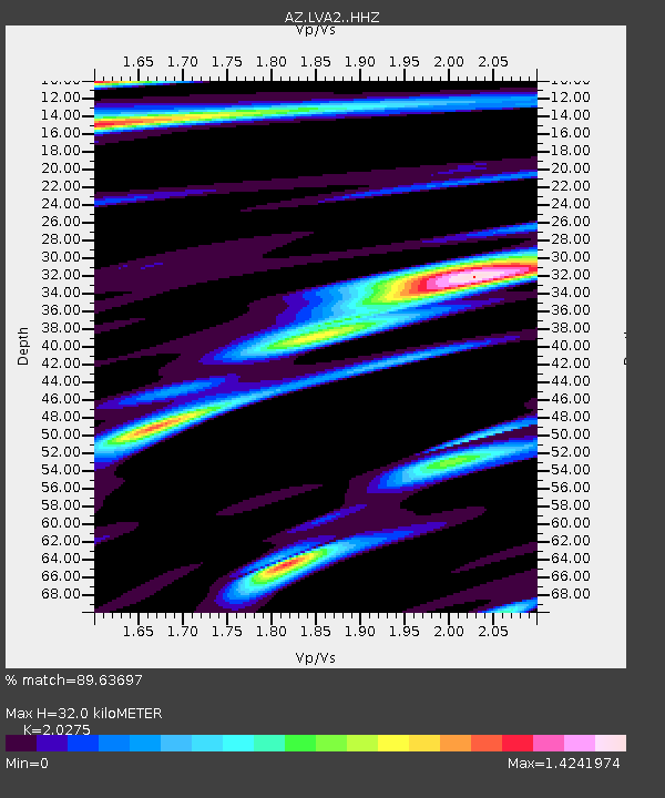
| Estimated Moho Depth: |
32.0 km |
| Estimated Crust Vp/Vs: |
2.03 |
| Assumed Crust Vp: |
6.264 km/s |
| Estimated Crust Vs: |
3.089 km/s |
| Estimated Crust Poisson's Ratio: |
0.34 |
|
| Radial Match: |
89.63697 % |
| Radial Bump: |
400 |
| Transverse Match: |
78.832245 % |
| Transverse Bump: |
400 |
| SOD ConfigId: |
18369291 |
| Insert Time: |
2019-06-13 09:05:01.083 +0000 |
| GWidth: |
2.5 |
| Max Bumps: |
400 |
| Tol: |
0.001 |
|

Signal To Noise
| Channel | StoN | STA | LTA |
| AZ:LVA2: :HHZ:20190530T09:09:25.993011Z | 14.619642 | 1.7853462E-6 | 1.2211969E-7 |
| AZ:LVA2: :HHN:20190530T09:09:25.993011Z | 5.0065475 | 7.2840066E-7 | 1.4548961E-7 |
| AZ:LVA2: :HHE:20190530T09:09:25.993011Z | 6.1515107 | 1.4212234E-6 | 2.3103648E-7 |
| Arrivals |
| Ps | 5.6 SECOND |
| PpPs | 14 SECOND |
| PsPs/PpSs | 20 SECOND |


