You are here: Home > Network List > AZ - ANZA Regional Network Stations List
> Station SMER AZ.SMER > Earthquake Result Viewer
SMER AZ.SMER - Earthquake Result Viewer
| Earthquake location: |
El Salvador |
| Earthquake latitude/longitude: |
13.1/-89.4 |
| Earthquake time(UTC): |
2019/05/30 (150) 09:03:31 GMT |
| Earthquake Depth: |
10 km |
| Earthquake Magnitude: |
6.6 Mi |
| Earthquake Catalog/Contributor: |
NEIC PDE/at |
|
| Network: |
AZ ANZA Regional Network |
| Station: |
SMER AZ.SMER |
| Lat/Lon: |
33.46 N/117.17 W |
| Elevation: |
355 m |
|
| Distance: |
32.4 deg |
| Az: |
313.315 deg |
| Baz: |
122.018 deg |
| Ray Param: |
0.078662105 |
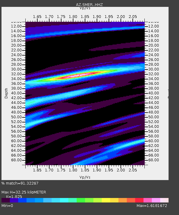
| Estimated Moho Depth: |
32.25 km |
| Estimated Crust Vp/Vs: |
1.83 |
| Assumed Crust Vp: |
6.264 km/s |
| Estimated Crust Vs: |
3.432 km/s |
| Estimated Crust Poisson's Ratio: |
0.29 |
|
| Radial Match: |
91.32267 % |
| Radial Bump: |
270 |
| Transverse Match: |
75.95133 % |
| Transverse Bump: |
374 |
| SOD ConfigId: |
18369291 |
| Insert Time: |
2019-06-13 09:05:03.569 +0000 |
| GWidth: |
2.5 |
| Max Bumps: |
400 |
| Tol: |
0.001 |
|
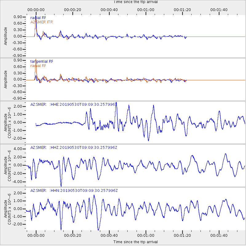
Signal To Noise
| Channel | StoN | STA | LTA |
| AZ:SMER: :HHZ:20190530T09:09:30.257996Z | 10.110572 | 1.3806438E-6 | 1.3655446E-7 |
| AZ:SMER: :HHN:20190530T09:09:30.257996Z | 3.8436995 | 5.418969E-7 | 1.4098316E-7 |
| AZ:SMER: :HHE:20190530T09:09:30.257996Z | 6.1758766 | 7.448807E-7 | 1.2061133E-7 |
| Arrivals |
| Ps | 4.6 SECOND |
| PpPs | 14 SECOND |
| PsPs/PpSs | 18 SECOND |


