You are here: Home > Network List > UU - University of Utah Regional Network Stations List
> Station FORU South Mineral Mountains, UT, USA > Earthquake Result Viewer
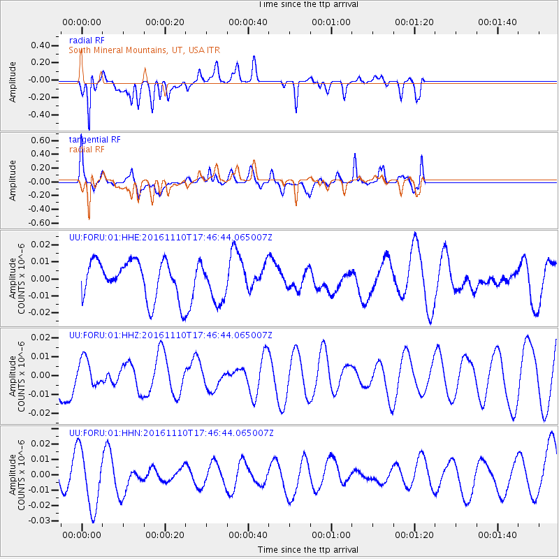
FORU South Mineral Mountains, UT, USA - Earthquake Result Viewer
*The percent match for this event was below the threshold and hence no stack was calculated.
| Earthquake location: |
Fiji Islands Region |
| Earthquake latitude/longitude: |
-20.4/-178.2 |
| Earthquake time(UTC): |
2016/11/10 (315) 17:35:38 GMT |
| Earthquake Depth: |
546 km |
| Earthquake Magnitude: |
5.6 MWW |
| Earthquake Catalog/Contributor: |
NEIC PDE/NEIC COMCAT |
|
| Network: |
UU University of Utah Regional Network |
| Station: |
FORU South Mineral Mountains, UT, USA |
| Lat/Lon: |
38.46 N/112.86 W |
| Elevation: |
1840 m |
|
| Distance: |
84.7 deg |
| Az: |
45.773 deg |
| Baz: |
238.881 deg |
| Ray Param: |
$rayparam |
*The percent match for this event was below the threshold and hence was not used in the summary stack. |
|
| Radial Match: |
73.66084 % |
| Radial Bump: |
400 |
| Transverse Match: |
67.60355 % |
| Transverse Bump: |
400 |
| SOD ConfigId: |
1858631 |
| Insert Time: |
2016-11-28 15:41:48.448 +0000 |
| GWidth: |
2.5 |
| Max Bumps: |
400 |
| Tol: |
0.001 |
|
Signal To Noise
| Channel | StoN | STA | LTA |
| UU:FORU:01:HHZ:20161110T17:46:44.065007Z | 0.42027348 | 6.963899E-9 | 1.6569922E-8 |
| UU:FORU:01:HHN:20161110T17:46:44.065007Z | 2.9650505 | 1.9145112E-8 | 6.456926E-9 |
| UU:FORU:01:HHE:20161110T17:46:44.065007Z | 1.0669173 | 1.1642623E-8 | 1.0912395E-8 |
| Arrivals |
| Ps | |
| PpPs | |
| PsPs/PpSs | |


