You are here: Home > Network List > C1 - Red Sismologica Nacional Stations List
> Station MT09 Talagante > Earthquake Result Viewer
MT09 Talagante - Earthquake Result Viewer
| Earthquake location: |
El Salvador |
| Earthquake latitude/longitude: |
13.1/-89.4 |
| Earthquake time(UTC): |
2019/05/30 (150) 09:03:31 GMT |
| Earthquake Depth: |
10 km |
| Earthquake Magnitude: |
6.6 Mi |
| Earthquake Catalog/Contributor: |
NEIC PDE/at |
|
| Network: |
C1 Red Sismologica Nacional |
| Station: |
MT09 Talagante |
| Lat/Lon: |
33.78 S/70.99 W |
| Elevation: |
1371 m |
|
| Distance: |
49.8 deg |
| Az: |
159.901 deg |
| Baz: |
336.301 deg |
| Ray Param: |
0.06845822 |
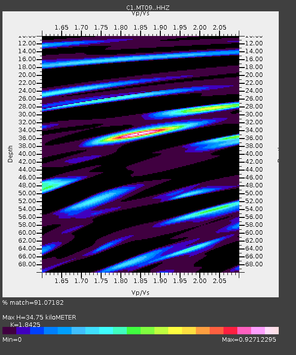
| Estimated Moho Depth: |
34.75 km |
| Estimated Crust Vp/Vs: |
1.84 |
| Assumed Crust Vp: |
6.481 km/s |
| Estimated Crust Vs: |
3.517 km/s |
| Estimated Crust Poisson's Ratio: |
0.29 |
|
| Radial Match: |
91.07182 % |
| Radial Bump: |
385 |
| Transverse Match: |
75.96584 % |
| Transverse Bump: |
400 |
| SOD ConfigId: |
18369291 |
| Insert Time: |
2019-06-13 09:05:47.683 +0000 |
| GWidth: |
2.5 |
| Max Bumps: |
400 |
| Tol: |
0.001 |
|

Signal To Noise
| Channel | StoN | STA | LTA |
| C1:MT09: :HHZ:20190530T09:11:53.01001Z | 3.272168 | 1.4208686E-6 | 4.342285E-7 |
| C1:MT09: :HHN:20190530T09:11:53.01001Z | 2.7286775 | 1.1803066E-6 | 4.3255628E-7 |
| C1:MT09: :HHE:20190530T09:11:53.01001Z | 3.828658 | 1.3254942E-6 | 3.4620334E-7 |
| Arrivals |
| Ps | 4.8 SECOND |
| PpPs | 14 SECOND |
| PsPs/PpSs | 19 SECOND |


