You are here: Home > Network List > TA - USArray Transportable Network (new EarthScope stations) Stations List
> Station W20A Ramah, NM, USA > Earthquake Result Viewer
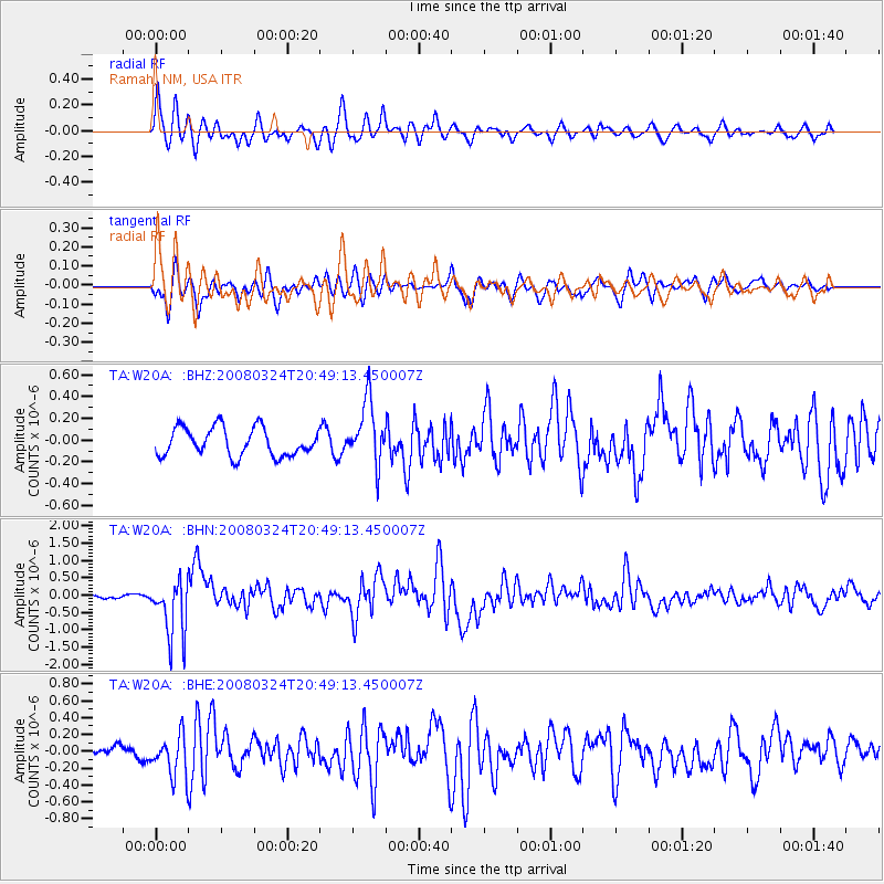
W20A Ramah, NM, USA - Earthquake Result Viewer
*The percent match for this event was below the threshold and hence no stack was calculated.
| Earthquake location: |
Chile-Bolivia Border Region |
| Earthquake latitude/longitude: |
-20.0/-69.0 |
| Earthquake time(UTC): |
2008/03/24 (084) 20:39:07 GMT |
| Earthquake Depth: |
120 km |
| Earthquake Magnitude: |
5.7 MB, 6.2 MW, 6.1 MW |
| Earthquake Catalog/Contributor: |
WHDF/NEIC |
|
| Network: |
TA USArray Transportable Network (new EarthScope stations) |
| Station: |
W20A Ramah, NM, USA |
| Lat/Lon: |
35.13 N/108.50 W |
| Elevation: |
2110 m |
|
| Distance: |
66.5 deg |
| Az: |
325.311 deg |
| Baz: |
139.25 deg |
| Ray Param: |
$rayparam |
*The percent match for this event was below the threshold and hence was not used in the summary stack. |
|
| Radial Match: |
77.44281 % |
| Radial Bump: |
400 |
| Transverse Match: |
69.28673 % |
| Transverse Bump: |
400 |
| SOD ConfigId: |
2504 |
| Insert Time: |
2010-03-06 23:05:06.640 +0000 |
| GWidth: |
2.5 |
| Max Bumps: |
400 |
| Tol: |
0.001 |
|
Signal To Noise
| Channel | StoN | STA | LTA |
| TA:W20A: :BHN:20080324T20:49:13.450007Z | 10.895708 | 8.3641623E-7 | 7.676566E-8 |
| TA:W20A: :BHE:20080324T20:49:13.450007Z | 2.4135664 | 2.4175498E-7 | 1.0016504E-7 |
| TA:W20A: :BHZ:20080324T20:49:13.450007Z | 2.2630348 | 2.903652E-7 | 1.2830789E-7 |
| Arrivals |
| Ps | |
| PpPs | |
| PsPs/PpSs | |


